Mt. Princeton (attempt) (14,197 ft)
For some crazy reason, myself, my wife, and a few friends decided to try tackling Mt. Princeton and Mt. Yale in one weekend. A friend volunteered use of his family's cabin in Taylor Park for the weekend, and despite the fact that Taylor Park is about an hour away from each trailhead, we decided it was going to be more fun (and cheaper) than staying in a hotel in Buena Vista. Unfortunately, the weather didn't cooperate.
I've done a number of peaks in the September/October time frame before, and mostly they're quite pleasant! The weather is a touch cooler, sometimes with a little snow on the peak, but overall it doesn't interfere with the hike. Somehow, this year seems to be a bit different; this became obvious a few weeks prior, as our Mt. Bierstadt hike was bitter cold and windy (and the weather in Denver starting cooling fast too).
Since we had already planned the weekend, we threw caution to the wind and headed for Taylor Park on a dreary and rainy Denver Friday afternoon. By the time we crossed Cottonwood Pass into Taylor Park, it was snowy and cold, and a dense fog (or cloud) sat atop the pass, making the Taylor Park side incredibly exciting (nothing quite like blind hairpin turns with no reflectors on the side of the road with 2 feet of visibility)!
The following morning, we left Taylor Park around 5:30am to try to reach the Mt. Princeton trailhead by 6:30am. The Pass was once again socked in with fog, which made for slow going, but once we crossed over, Maxwell Park (the Buena Vista valley) seemed much clearer than Taylor Park to the west - this bolstered our hopes a bit, however we caught sight of the northern slopes of Princeton and they were quite covered in snow.

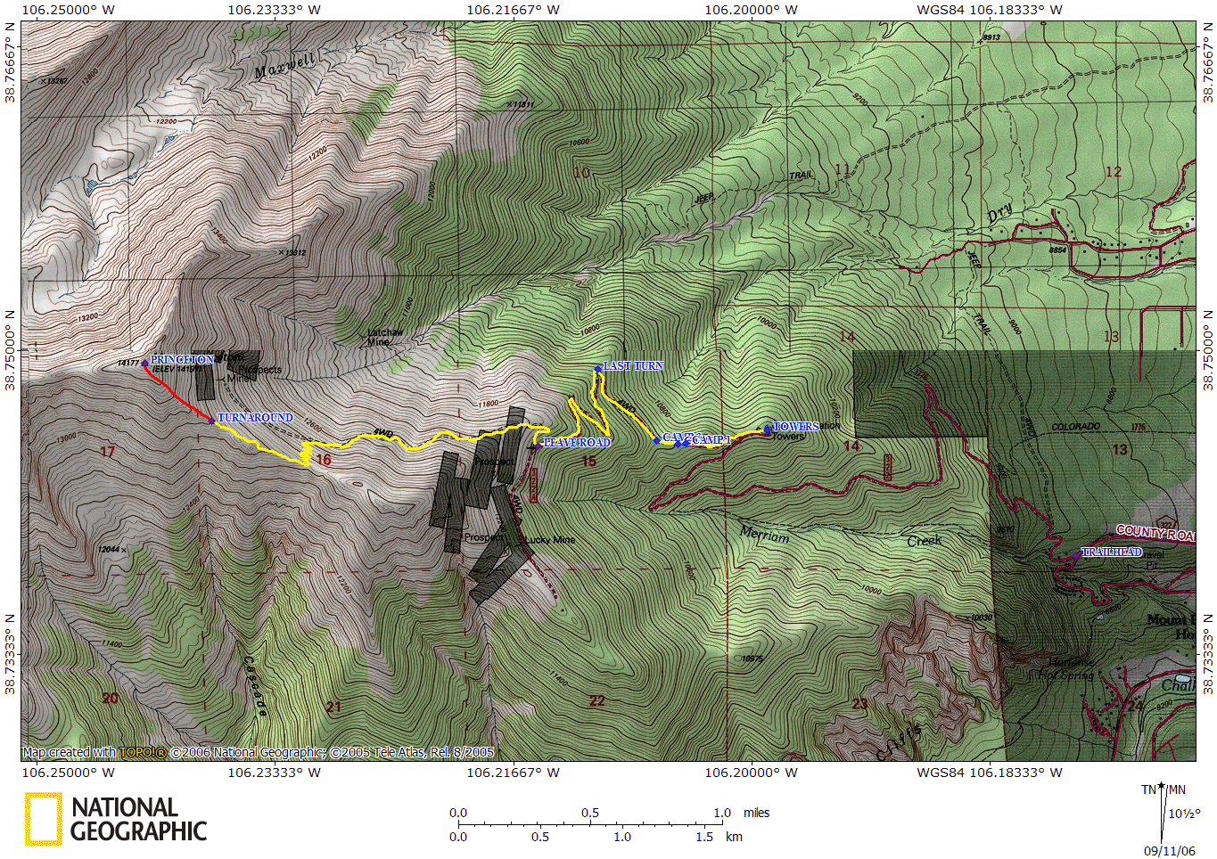
We reached the official Mt. Princeton trailhead just before sunrise and started heading up the 4WD road in our 4Runner. I had some concerns, considering that Roach's Fourteeners book claims that, "If you value your vehicle, park here." In actuality, however, the road was quite passable - a smooth road bed with a lot of drainage burms (which does require high clearance to get over) and probably is passable with just 2WD high clearance vehicle. The one catch, as on most 4WD roads, is that passing a vehicle going the other way is tough. We only encountered one vehicle coming down as we came up (a Subaru Forester), and thankfully could crawl up the side of the road a touch to let them pass narrowly. There are only a few switchbacks on the way up to the radio towers to allow easy passage, and only a few pull offs; otherwise it isn't too bad.
We made it to the radio towers a little before 7:00am, just below 11,000 ft. Not knowing exactly what was ahead in terms of parking or turning around, we parked here. On my maps, I marked three additional camping/parking spaces up the road, as well as the last decent place to turn a vehicle around in case all the spots are full. The road does get progressively narrower as you climb up, so I'd recommend not going any further than the first switchback past the radio towers.

We started hiking up the road at about 7:10am. From the radio towers, you could see the summit, and a cloud was parked squarely over the top, as well as to Mt. Harvard to the north, yet Buena Vista was mostly clear, except for fog covering the valley floor. We left from the 4WD road a little before 8:00am, covering about 1.5 miles in very little time - then the trail got serious. The spur off the road ascended steeply up to the grassy shoulder above us, where the summit of Princeton became visible once again. We didn't spend long hiking on a nice trail through the tundra before the trail turned into a boulder-hop on talus. I noticed on a 1994 USGS Topo Quad of the area that it indicates that the trail to the mine at 13205 ft below the summit is a 4WD road - this is most definitely not the case; Roach's book even calls it Class 1 until the trail splits and heads to the saddle. Instead, this was definitely easy class 2 boulder stepping and hopping on a semi-defined trail (which, thanks to the snow, was nice and icy for us). After about a quarter of a mile, the trail became slightly more defined and easier to follow, but the snow also got a bit deeper (only a few inches), so trailblazing was a bit of a challenge. We were obviously the first up the mountain since the snow, as there were no footprints to follow at all in the thin snow - in fact, we only saw four others on the mountain that day (I guess everyone else decided to sleep in and stay warm)!

By this point, a very strong gusty wind was hitting us from the south - strong enough to require a bit of effort not to get blown over. We threw on our wind/rain shells, which helped a bit, but we'd forgotten to bring our ski goggles so the wind caused our eyes to tear up a bit.
The trail continued to ascend gently up the valley wall until it broke from the trail to the old mine and switchbacked up to the saddle. At this point, the route was pretty well cairned so it wasn't hard to ascend. We made it to the ridge by 9:30am. Once up on the ridge, the wind returned and the trail disappeared. We occasionally spotted cairns, but we had reverted back to boulder hopping again, except this time with more snow on each rock. We'd slip and fall occasionally, then notice a cairn about 5 feet above us, realizing that we're not really on the proper path. After a few hundred feet of this, the path leveled out and the boulder hopping eased up - it seemed to ebb and flow like this, but then our luck changed.

By about 10:30am, we'd made it to about 13,400' but the cloud that had been parked over the summit all morning had finally pushed past it - a storm was clearly on its way. Over the ridge, we could see that a snow storm was moving this way quickly, and our clear blue skies had given way to dark gray. Last year, Lisa and I had heard thunder on Shavano this early in the morning, plus I've been pinned down by strong snowstorms before; despite the fact that it pained all of us to give up after making it this far, we didn't want to risk the weather - the mountain isn't going anywhere, and we can tackle it another day. We turned around.
As we started back down the mountain, it started to snow pretty hard (which was made made even more exciting by the continuous wind we'd had the entire hike). We passed a group of three that were still ascending (that we'd passed while ascending earlier) and they had decided to keep going (I found their trip report two days later - they summited!). Only one other person was on the mountain that day, and he was cruising past us - we watched him ascend, touch the top, then rapidly descend (eventually passing on his descent when we were about half a mile from the car).

The snow and wind was steady for about 30 minutes as we descended. The storm thinned out a bit at our altitude, but we could look back and see that part of it still enveloped the summit; the other part was moving southward through Maxwell Park towards Salida. The boulder hopping was a little easier now, as some of the snow and ice had melted at lower elevations.

We were back to the 4WD road by about 11:50am. By now, it was clear that the storm was merely transitory, and we were all bit disappointed that we hadn't summited - but we knew we made the right decision at the time, and Mt. Princeton isn't going anywhere anytime soon. (Besides, as Jim pointed out, next time we try it, it will be a tiny bit shorter, since the Rockies are slowly shrinking.) We were back at the car by about 12:45pm, and headed down to the Coyote Cantina in Johnson Village for a semi-celebratory water (Lisa), PBR (Jim), Fat Tire (Lonny), and Corona (Brian).
All things considered, this wasn't a bad hike. The trail was fairly gentle and got you up the mountain slow and steady, and if there hadn't been snow or gale-force winds, it probably would've been more enjoyable; but by the time we were snowy-boulder hopping beyond the saddle, I had had about enough already - the storm was just the tipping point. I look forward to tackling this spectacular mountain in the future!