Hiking Switzerland's Jungfrau Region (with Kids)
Intro
In a past life (i.e. pre-kids), my wife and I hiked the Walker's Haute Route, a trail that travels from Chamonix to Zermatt by traversing mountain passes and pristine Swiss valleys. We've wanted to go back ever since. Now, fifteen years later, our kids were finally old enough to experience something similar. Our girls, aged 9 and 12, had hiked in Colorado quite a bit, but had never seen the Alps and the amazingly snargly (our word for insanely steep and jagged) peaks.
We wanted to recreate the experience of the Haute Route on our trip; not necessarily hiking 5,000 vertical feet (1,524 m) every day, but the experience of moving from place to place and appreciating that your movement between these locations was by your own feet, not by train or cable car. So we set out to plan a similar style trip that was more family friendly. Like the Haute Route, we planned to stay in a hotel every night (because we're old and like beds and showers) and wanted to hike at least a few miles every day.
We set our sights on the Jungfrau region of Switzerland and began planning a trip centered around it. We wanted to explore the entire region, but break the trip into bite-sized chunks that our girls (9 and 12) could handle without too much complaining - so we planned to hike from town to town, breaking the extremely long distances up with the aid of Swiss railways or cablecars.
This write up is to help other families (or individuals) that want to do something similar. We realize that we're weird and I doubt that anyone is crazy enough to want to hike through the Swiss Alps with a 9 and 12 year old from town to town…but if you're the other family in the world that DOES, maybe this will be helpful. Either way, enjoy!
Costs
Switzerland is expensive. Staying in hotels in Switzerland is expensive too. I didn't a lot of the cost details here, as your lodging and dining preferences will vary significantly from that of a (my) family of four. This trip was also a major anniversary for Lisa and I - so we splurged. Your mileage (or rather cost) will obviously vary - but prepare for some sticker shock as you're finding lodging along the way. For what it's worth, I used booking.com to find most of our lodging, just because it was "easy" to search each town. You can probably find better deals (or more unique lodging) by searching each town's lodging options directly. Hey - maybe if this writeup saves you time you can spend more time searching for unique lodging options!
Transportation Costs
For transportation, we debated different options including the Jungfrau Travel Pass which would cover all transit on all rail lines and lifts in the Jungfrau region. In the end, we opted for the SBB Swiss Half Fare Card (for 240 CHF for my wife and I) which allowed the girls to travel for free and cut our fare in half. Since we started our journey in Zürich, the train to and from the Jungfrau region was the most expensive fare we'd pay except for our trip up to Jungfraujoch (which the Swiss Half Fare cut in half for us).
Depending on your specific route, it's worth doing the analysis to see which option would be more cost effective. Here's how our fares broke down:
SBB Costs
| Day | Route/Destination | Cost (CHF) |
|---|---|---|
| 0 | Zürich Flughafen → Zürich, Feldeggstrasse (Airport to hotel) | 14.00 |
| 1 | Zürich → Mürren | 95.60 |
| 1 | Mürren → Allmendhubel | 14.00 |
| 2 | Mürren → Stechelberg (Schilthornbahn) | 11.80 |
| 3 | Wengen → Männlichen (side trip) | 58.00 |
| 5 | Alpiglen → Grindelwald | 18.00 |
| 6 | Grindelwald, Firstbahn → First | 38.00 |
| 7 | Grindelwald → Zürich | 87.80 |
| 8 | Zürich, Feldeggstrasse → Zürich Flughafen (hotel to Airport) | 7.00 |
As a side note, the app was phenomenal at helping find the right fare and purchasing it before getting on any train. We never once fumbled around on a kiosk in any train station and instead were able to easily pre-purchase tickets (with our half fare card) ahead of time.
Another note along the line of costs: with one notable exception, we never once needed cash on our trip. We used Apple Pay everywhere we went. There were a few hotels where I handed them a physical credit card at check in, but in nearly every restaurant or hotel we were able to tap with our iPhones to pay (which was amazingly convenient). The exception was this: we passed several self-pay cheese refrigerators along our hike that you could only pay with Twint (the Swiss equivalent of Venmo) or cash. It would have been worth getting some cash just for the cheese along the way!
Our Trip Philosophy
Where possible, we wanted to travel on foot. But we had to think about the strength and stamina of our girls and what they could or would be willing to hike in a day. We had done some 1,500 ft (457 m) elevation gain training hikes back in Colorado at altitude (around 11,000 ft / 3,353 m) which was far higher than we'd be in Switzerland - and there was a lot of whining and complaining about it; our girls are not avid hikers like we are. But we knew they had the ability to do the elevation and distance.
In hindsight, they could have hiked more than we ended up hiking. The descent on the Eiger trail from Eigergletscher was probably the toughest day, but that was more due to the activities at Jungfraujoch in the morning and the fact that we didn't start our descent until after 1:00pm - plus the trail was rocky and somewhat tedious. The next day, the girls knocked out the same elevation drop over an additional 1.5 miles (2.4 km) without any complaining at all.
Pack List
We used Zurich as our staging area for our trip. Because we stayed at the same hotel before and after our trip, they were extremely gracious and willing to hold a bag for us while we hiked through the Jungfrau region. This allowed us to leave some of our stuff from the flight and other legs of our trip in Zurich and not carry it while hiking. We used these cheap duffel bags to hold our backpacks when we flew which also allowed us to bring some extra gear for before/after the hike.
The weather started foggy, rainy, and cold and ended near 80º F (27º C) - plus we had just traveled from Iceland where it was even rainier - so our gear had to cover a wide range of temperatures and weather conditions.
Here's what we brought on the trail with us.
- Backpacks:
- Osprey Men's Stratos 34 Pack - Brian's pack
- Opsrey Women's Sirrus 36 Pack - Lisa's pack
- REI Tarn 40 Pack
- I personally wouldn't recommend this pack - it was too large and floppy for my 9 year old with not enough ways to cinch down the load on her small body
- Another ancient REI 40 liter kids backpack
- Clothes
- We basically had 2 sets of clothes each - we washed our clothes about every other night in the sink of where we were staying and hung our clothes with a portable clothes line.
- Each of us had hiking pants, 2 pairs of hiking socks, base upper layer, 2 long sleeve hiking shirts, a top warm layer, long underwear, and pajamas
- We also brought swimsuits (our first hotel had access to a pool in the town of Mürren)…but we never ended up using them.
- Outerwear
- Rain coat
- Rain pants
- Down puffer coat
- We bought both of the girls a used puffer on eBay since they're super warm, light, and easy to pack
- Sunday Afternoons Ultra Adventure Hat
- As dorky as this hat may look, it's my go-to hat these days. I've realized that the sun beating down on my neck makes me more fatigued and this does a great job to keep my neck shaded. Plus, the chin strap means it stays on even when it's super windy.
- Pack rain cover
- We picked up two cheap pack covers on Amazon for the girls' packs. The Osprey packs had a built-in pack cover.
- Warm fleece beanie hat
- Gloves
- Other Miscellaneous Things
- Bandanas
- Lisa picked up this trick from following thru-hiker blogs. We each had a bandana that would act as a “napkin” or a makeshift tablecloth for our laps to keep us from getting food on our clothes (to mitigate against bears and other animals smelling your food on your clothes...not a big concern in the Alps)
- Titanium Spork
- Having our own spork made certain grocery store items easier to deal with - like picking up a few containers of yogurt for a snack
- Phone
- We used Gaia GPS on our phones for tracking our route -- although it was incredibly well signed. The Gaia GPS app's base Overland Topo map was fantastic, and you could also load in the Swiss Topo maps as well.
- Phone charger
- A used a Spigen 4 Port charger which allowed me to charge my phone, Lisa's phone, my Sony camera, and one of the girls Kindle's (if needed). It was nice having a single multi-port charger rather than lots of chargers, especially since outlets were rare. Lisa carried a one-port charger as well as a few places we stayed required us to split up in separate rooms.
- Kindle (both of the girls had a kindle for reading)
- European plug adapter plus a short 1ft outlet extender
- Since outlets are often a sparse quantity, the outlet extender allowed me to plug in several things using just a single plug adapter
- Toiletries (packed in a lightweight stuff sack)
- Camelbak bladder and off-brand extra bite valves (my daughter likes to chew on them…and break them)
- Sunscreen
- Ziplock bags - for additional electronics and passport protection in the rain
- When we hiked Jotunheimen National Park in Norway, we had a pack cover blow off our pack, leaving everything in the pack completely soaked. We've learned since then to at least put our passports in a Ziploc to keep them dry.
- Powdered laundry detergent
- Bandanas
- Food
- I talk about this a bit more down below, but we always had a selection of granola bars, gel chews, and fresh snacks purchased in town
- Camera
- We took lots of photos with our iPhones, and they come out great, but no amount of smartphone processing will match the quality and control (and optical physics) of a big camera…so I lug this beast around with me on every hiking trip.
- Sony Alphy 7 IV - I switched to the Sony A7 from Nikon about 3 years ago and have absolutely loved it
- Sony FE 24-105mm F4 G OSS Zoom Lens - I just carry one lens; I don't like swapping around lenses on the trail, and I've found this to be a great do-everything lens
- USB-C chargeable spare battery - I like this spare battery for my camera because I can just plug it in via USB-C cable instead of charging in the camera directly
- Peak Design Capture Camera Clip - This is, hands down, the best way I've found to carry an SLR camera on the trail. The clip attaches securely to your backpack strap, then the camera hangs from it. This distributes the weight of the camera on your pack straps and keeps the camera out of the way. I've tried several other ways of carrying my camera and this doesn't create any extra strain.
- Camera rain sleeve
- Lens cleaning wipes - with as much rain as we hiked through, having pre-moistened lens cleaning wipes was the easiest way to get the raindrops back off my lens
Food and Water
We had two significant food constraints for our hike: my wife and our girls are all gluten-intolerant and my girls are kids - and kids are occasionally picky about what they eat. We brought a lot of “trail food” with us from the US, including granola bars, gel chews, and M\&Ms (as trail motivation) just to ensure that we had some food for the first few days. Every other day we stopped in at the COOP grocery store and picked up some cheese, sausage, and trail snacks that the girls picked out - this ended up working well for us. Our daily lunch was typically cheese, apples, and sausage on the trail somewhere. Honestly, we ended up not eating as many of the granola bars we brought - the girls were more interested in the local snacks we picked up (including Swiss chocolate), but we spent a good bit of time browsing the COOP website to understand what gluten-free options were available.
We all hiked with CamelBak bladders for water - there was occasional water in towns along the trail, but we rarely filled up there (it's hard to take the dry Colorado hiker out of Colorado).
Hiking and Traveling with Kids
Prior to the trip, we did several training hikes with the girls in Colorado. Our oldest daughter (12) has the personality of "I will do this thing no matter what, even if I hate it." this attitude translates to someone that will just hike and get it done. She's gone backpacking with my wife a few times and was capable of hiking long distances (without too much grumbling). In the end, she actually enjoys the actual hiking, she just doesn't like the idea of hiking. My 9 year old, on the other hand, is very capable of hiking but whines a lot; we motivated her by M&Ms and or gel chews along the trail. Everyone carried their own clothes, warm layers, snacks, and water in their packs - this meant that everyone's pack was a little over 10 pounds (4.5 kg). The girls did really well with this weight and it helped them in realizing that anything they brought with them, they'd have to carry.
For entertainment on the planes and train from Zürich, each of the girls has a "travel phone" - a set of old cast-off iPhone 8's that still (mostly) work with a pop socket on the back so it can be propped up. The girls used these phones (along with some cheap wired headphones and a Lightning to 1/8" headphone adapter) to watch movies. The phones are locked down to prevent just about anything else from running on them, with the exception of a clock app which we can use as a nightstand clock so the girls can see what time it is at night. (We didn't bring anything larger than a phone either and was content watching movies on the plane on the small screen.)
Everywhere else we went kept the girls pretty entertained: One of the true delights we found in Switzerland was that nearly everywhere we stopped to eat had an impressive playground - and our girls are old enough to play safely by themselves. This enabled Lisa and I to grab a coffee or alpine cheese snack while the girls explored an elaborate obstacle course or bounced on in-ground trampolines, often with other kids.
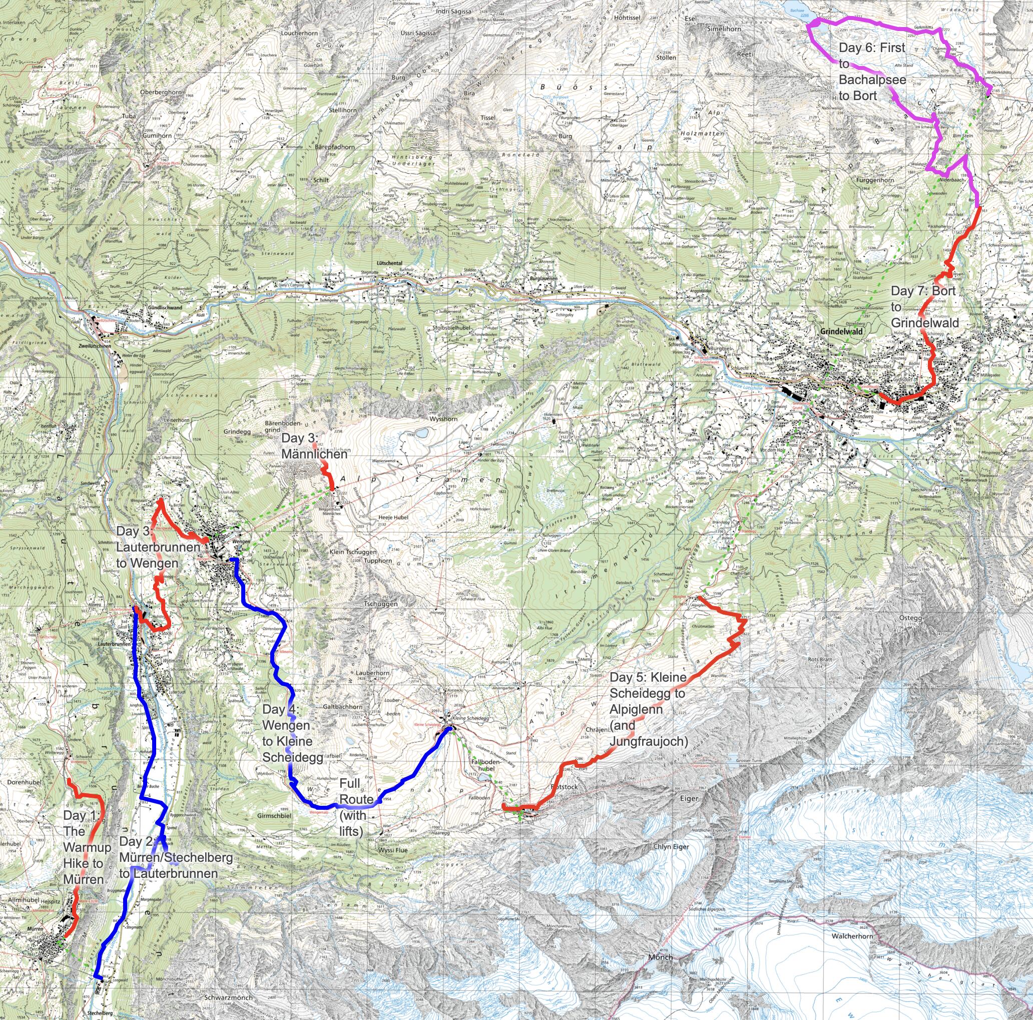
Route
You can view the route online using CalTopo, Gaia GPS, or download the route files for use on your own device
- View on CalTopo
- Download GPX Track
- Download GeoJSON file with all routes
- Download JPG Topo Map with route overlay
| Segment | Dist | Time | Asc | Desc |
|---|---|---|---|---|
| Day 1: Winteregg to Mürren | 1.54 mi (2.5 km) | 47m 38s | 79 ft (24 m) | 0 ft |
| Day 2: Stechelberg to Lauterbrunnen | 4.7 mi (7.6 km) | 4h 33m | 464 ft (141 m) | 659 ft (201 m) |
| Day 3: Lauterbrunnen to Wengen | 2.6 mi (4.2 km) | 2h 30m | 1,523 ft (464 m) | 15 ft (5 m) |
| Day 3: Männlichen summit hike | 0.94 mi (1.5 km) | 1h 28m | 294 ft (90 m) | 265 ft (81 m) |
| Day 4: Wengen to Kleine Scheidegg | 4.2 mi (6.8 km) | 4h 23m | 2,454 ft (748 m) | 0 ft |
| Day 5: Eigergletscher to Alpiglen | 3.8 mi (6.1 km) | 3h 48m | 184 ft (56 m) | 2,422 ft (738 m) |
| Day 6: First to Bort | 5.3 mi (8.5 km) | 5h 18m | 392 ft (119 m) | 2,362 ft (720 m) |
| Day 7: Bort to Grindelwald | 2.5 mi (4.0 km) | 1h 29m | 0 ft | 1,661 ft (506 m) |
Total Statistics:
- Total Distance: 25.40 miles (40.9 km)
- Total Ascent: 5,390 ft (1,643 m)
- Total Descent: 7,384 ft (2,251 m)
- Total Time: 23h 56m
Day 1: The Warmup Hike to Mürren
We arrived in Zürich the day before we headed up to the Jungfrau region and stayed at a hotel. Our flight arrival time was too late in the day to try to make it all the way up into the mountains, so we departed the next morning.
We took the train from Zürich to Bern, then to Interlocken before taking a final train up to Lauterbrunnen, all of which was about a 3-hour journey. Once in Lauterbrunnen, we took the Mürrenbahn cable car up to Grütschalp to catch another train that would stop in Winteregg and Mürren. The astonishing thing to me was how easy it was to buy a (single) ticket that covered these various legs of travel, and how easy it was to transfer between trains, lifts, and more trains.
We opted to get off the train at Winteregg to stop and have lunch. We had still had some leftovers from dinner the night before and some food we'd brought from home, so we found a bench along the trail and ate our lunch looking across the valley floor towards Trümmelbach and Wengen (when the clouds allowed us to see) since the Winteregg restaurant had very clear signs (like most restaurants we saw along the trail) of “no picnicking”.
Rather than get back on the train, we decided that the flat 1.6 mile (2.6 km) hike from Winteregg to Mürren would be a great way to "warm up" for the trip. The weather was pleasant (off and on rainy, but not too cold) and the views were stunning, so off we went.
Along the hike we had amazing views across the valley of where we would be hiking in a few days (Wengen) and along the trail (which paralleled the rail line) we found lots of moss and tiny snails which kept the girls entertained. We arrived in the quiet car-free town of Mürren about 45 minutes later, wandering through town until we found our hotel and popped into a few shops to see if we could find some warmer leggings for the girls since the temperatures were surprisingly cool (it was about 48º F / 9º C in the rain).
After dropping our gear at the hotel, we took the Allmendhubelbahn funicular up to Allmendhubel which was a restaurant and playground about 1,000 feet (305 m) above Mürren, offering (when the clouds parted) amazing views of Jungfrau peak and Wengen across the valley. The girls played on the playground while Lisa and I hiked around the point to admire the views of the valley below. After descending back down on the funicular, we decided to stop into the Mürren Annual festival where we had a great dinner of Swiss sausage, raclette, and potatoes while listening to a local brass band.
Day 2: Mürren/Stechelberg to Lauterbrunnen
The next morning the sky was a bit clearer (which also meant the temp was much cooler at about 42º F / 6º C), offering views across towards our future destinations of Wengen and Kleine Scheidegg. We took the Stechelberg cable car (the steepest cable car in the world) 2,500 feet (762 m) down to the Lauterbrunnen valley floor and started our hike towards the town of Lauterbrunnen. This valley is known as “the valley of 72 waterfalls” - and that was a fairly accurate description as they came cascading down both sides of the sheer valley walls. We also saw dozens of paragliders (launching from up in Mürren) and base jumpers (launching directly over our heads) coming down to the valley floor. If we did this again, we'd probably hike down to Gimmelwald and catch the cablecar from there, just to get more high mountain scenery.
This hike was truly meant as our warm up hike for the trip as it gently descended about 700 feet (213 m) down into Lauterbrunnen over the course of 4 miles (6.4 km).
Our hike started in the shadows of the high cliffs that went straight up in both directions, with the valley floor no wider than 0.25 miles (0.4 km). The trail followed the river in the woods and offered amazing views of the mountains and cliff faces above us with a steady stream of paragliders (and BASE jumpers) dropping into the valley as we hiked. We stopped at a playground at a campground for the girls to find entertainment with a teeter totter / seesaw (since these things are impossible to find in the US these days, despite the fact that Lisa and I grew up with them) before visiting Trümmelbach Falls.
This waterfall was absolutely amazing; we took a short funicular that was built in 1913 up inside the mountain itself, then walked down through the 10 different cascades that were visible. It was very wet in spots (like we should have put our rain gear on) and extremely loud and overwhelming inside the noisy caves (with the powerful water) - but absolutely worth the stop.
Trümmelbach Falls marked about the halfway point between Stechelberg and Lauterbrunnen, and afterwards the trail became much more crowded (presumably everyone was walking to and from the falls). Our hike ended at the (surprisingly busy and not car free) town of Lauterbrunnen (where we had started the day before) and where we enjoyed probably the best fondue of our entire trip!
Day 3: Lauterbrunnen to Wengen
We left Lauterbrunnen under cloudy skies and started our hike up to Wengen, 1,600 feet (488 m) above us on a shelf on the eastern side of the valley. We had two options to climb: one route that was a more direct path up from Lauterbrunnen with extensive switchbacks, and another route which swung wider up the hill to the north and traveled through Wengwald. We chose the path through Wengwald - it was a bit longer but seemed to offer a less steep climb than the switchbacks, and possibly a more scenic route.
The 2.6 mile (4.2 km) trail climbed through town first on roads and then onto a wide gravel path. At about 2,978 feet (908 m), we lost the trail completely and started to hike towards a house by accident, only to realize that the trail continued (faintly) to follow the map (precisely) and cut down a short hill under a tree along the grass. The trail here was just a worn grass path and easy to miss (probably because this path is less often traveled).
As we approached Wengen, we passed through a smaller town of Wengwald (town isn't the right word…it's named on the map and there was maybe 8 houses…neighborhood maybe?) with lots of small houses and farms (and deviated from the trail a bit here too), following the road into the town of Wengen - stopping at the Wengen church to eat lunch with a panoramic view of the valley below.
Pro tip: be wary of the top of the hour when the clock chimes if you're eating lunch. It scared the crap out of us and Lisa dropped an apple which, due to the steep slope below the bench, rolled quite far down into the garden below the church.
Once we arrived at the car-free town of Wengen, we took the Wengen-Männlichen aerial cableway which took us 3,200 feet (975 m) up onto a north-south ridge that divides the Jungfrau region between Lauterbrunnen and Grindelwald. From the top of this ridge, there was a restaurant, a few gondolas, and an absolutely amazing playground featuring a two-story tall wooden cow. Before playing on the playground, we decided to hike the steep 300 foot (91 m) climb to the summit of Männlichen peak which offered amazing views of our entire trip down both sides of the dividing ridge: Mürren, Lauterbrunnen, Wengen, Jungfraujoch, Grindelwald, and Bort. The only part of our trip that wasn't visible was Kleine Scheidegg, a pass that was on the opposite side of the green Tschuggen peak along the ridge.
After poking around on the summit and admiring the breathtaking views in all directions, we hiked back down to the restaurant by the top of the lift and enjoyed a cappuccino on the deck while the girls played on the amazing playground. This side trip to Männlichen was absolutely worth it - the view from the summit was amazing since it gave us great perspective of the entire region and the playground kept the girls very entertained.
As a side note, I had considered hiking to Männlichen in our trip, but I couldn't make the logisitcs work. You can absolutely hike up from Wengen, but it would be an absolutely brutal and steep climb. Alternatively, we could have easily hiked over from Kleine Scheidegg, but after the steep climb up the pass it seemed like that might make for too long a day - and staying an extra night in Kleine Scheidegg was going to be too expensive.
We took the lift back down to Wengen and purchased 2 kugelbahn balls - a wooden ball about the size of a tennis ball - so the girls could race them down ten different marble runs scattered throughout town.
Day 4: Wengen to Kleine Scheidegg
The weather continued to improve. On our first day in the Jungfrau region it was cold, cloudy, and rainy. The following day it was cloudy but dry. Our hike up to Wengen had been cloudy, with a few breaks in the clouds to see the amazing peaks of the Jungfrau region. On this day, the skies were even more clear and we had a good bit of sunshine.
This was the toughest day of climbing. We started our 4.5 mile (7.2 km) hike out of Wengen up to the pass of Kleine Scheidegg (which crossed the same ridge as Männlichen which we visited via cable car the day before) and would climb 2,500 feet (762 m) during the day along the famous Lauberhorn World Cup ski track. Our trail followed the track of the railway up to Kleine Scheidegg but allowed us to wander through pastures of cows (so many cows) and stunning views of Jungfrau.
The trail climbed steeply but consistently up and out of the valley, first heading southbound until turning eastbound towards the pass. This turn to the east yielded the best views yet we'd had of Jungfrau and exposed Eiger to us again with a constant cloud billowing along its northern face.
The trail was wide and even and we were passed in both directions by cyclists and hikers along our way. It was hard not to keep stopping to admire the view.
We arrived at Kleine Scheidegg (6,764 ft / 2,061 m) and checked into our hotel, the historic Hotel Bellevue des Alpes which was built in 1840. The pass has only two hotels (Lodge Kleine Scheidegg and Hotel Bellevue des Alpes), the train station, and two or three other restaurants. We splurged on the hotel as we were celebrating our anniversary! We wandered up the ridge a bit towards Restaurant Grindelwaldblick for a post-hike snack - and the girls played on a tiny playground next to the restaurant.
Once the train stopped running for the day (after about 6pm) it was delightfully quiet and we got to watch a family of foxes wander around the train station while we ate dinner in the super-fancy dining room of the hotel. From our room, we had a view of our destination the next day: the small town of Alpiglen midway down the Eiger trail to Grindelwald below, as well as the high lift station at First and our lodging for the subsequent night at Bort.
Day 5: Kleine Scheidegg to Alpiglenn (and Jungfraujoch)
For reasons that I don't really understand, the Swiss like to build cable cars and railways to places that most people would say, “nope.” Between 1898 and 1912 a tunnel was built from Eigergletscher up to the saddle ridge between Mönch peak and Jungfrau peak, and now the Jungfrau Railway shuttles tourists up there on a daily basis. We took this train up to the Jungfraujoch which contains a set of touristy things like an observation deck perched high up on a rocky promontory called “The Sphinx”, an ice cave through the Aletsch glacier, a zipline, a tubing hill, and a trail that allows you to hike out to the Mönchsjoch Hut. We viewed the amazing Aletsch glacier, which is the largest glacier in the Alps and is about 14 miles (23 km) long and 2,969 ft (905 m) thick, explored the glacier a bit, and hiked through the amazing ice cave within the glacier itself. One of the highlights of the trip for our girls was the ice cave - and if we had to do this again, we would have hiked all the way out to the Mönchsjoch Hut for coffee or lunch. This, however, likely would have required some form of traction device (like microspikes) as the snow/ice was slippery (which made for many attempts to glisade on the way back to the Sphinx...which generally didn't work....but entertained everyone else around us.)
After our time at Jungfraujoch, we took the train back to the Eigergletscher station (about 1,000 ft / 305 m above Kleine Scheidegg) and explored the area a bit, introducing ourselves to some cows that were very curious about us and hiking along the lateral moraine of the (now retreated) Eiger glacier before eating lunch.
We began our descent of the Eiger trail around 1:40pm - it was late in the day and we'd already had a pretty full morning, so we were already on the worn out side. The trail was rocky and narrow and we were occasionally held up by people posing along the trail for selfies. Our hike took us down 2,422 ft (738 m) over 3.7 miles (6.0 km) along the face of the Eiger. The view of the valley below and of Männlichen across the valley was amazing, as was the towering Eiger face above us, but the trail didn't offer much in the way of diversity - it was a steep downhill on sometimes slick gravel and rock. The trail crossed some pretty interesting glacial streams that carved deep into the mountain, evoking a similar feel to the Trümmelbach Falls we visited on our first hiking day (but on a much smaller scale).
We ended our hike at Alpiglen instead of continuing another 3 miles (4.8 km) (and 2,200 ft / 671 m) down and stopped for coffee and cheese at Berghaus Alpiglen before taking a train down to Grindelwald. If we had to do this to do over again, I think we would have stayed the night at Berghaus Alpiglen and hiked down to Grindelwald the next day. It was a wonderful place to stop for the afternoon, and it was much calmer than the chaos of the (not car free) Grindelwald. Lisa and I talked about this - the hike down to Grindlewald would have been too much for us: all of us were pretty baked by the time we arrived in Alpiglen - it was late in the afternoon (around 4:40pm) and the trail to this point was very tedious (slick rocky footing combined with somewhat monotonous and unchanging scenery). Another 2,000 feet (610 m) of descent would put us in Grindelwald in the early evening, and we were already pretty tired.
Grindelwald had their weekly street festival this night, since it was Wednesday. While it was fun to see tables out in the middle of the street, see street tobogganing, draw with chalk, and hear a dozen different bands scattered throughout, we were tired and wanted to get some rest. The music meant that we had to keep our window closed for the night, which made our room hot and stuffy - and was not nearly as calm and quiet as we typically prefer. Thankfully, Swiss windows are amazingly thick and kept the sound out quite well.
Day 6: First to Bachalpsee to Bort
The next morning, we took a cable car from Grindelwald up to First, 3,600 feet (1,097 m) above the town. The line to get on the gondola was already surprisingly long and that was even after we bought our tickets through the SBB app (had we bought our tickets at the window I suspect we would have waited 30-40 minutes to get into a gondola).
The gondola took us all the way up to First (it looks like it's 3 separate gondolas on the map, but these are just junction points where you can get on or get off the same gondola car) where the crowds were just as heavy as they were at the base. The crowds were much heavier than the relative isolation and quiet of all the other towns we visited so we didn't linger at the top of the lift; we quickly started hiking towards Bachalpsee Lake just to get away from the people (skipping the cliff walk). The trail was busy as well, but not nearly as chaotic as First station - and the trail was quite wide so we didn't get choked back behind other hikers.
We climbed about 500 feet (152 m) towards Bachalpsee Lake, often distracted by the amazing views of the valley below and mountains across from us. Most of our hike provided amazing views of the Eiger (which we'd hiked in front of the day before), Kleine Scheidegg, Männlichen, and Grindelwald, giving us perspective to “where we had been” along our trip so far. Mürren, Wengen, and Lauterbrunnen were no longer visible as they were on the other side of the Kleine Scheidegg ridge.
It took us a little over an hour to hike the 2 miles (3.2 km) to the lake. Once we arrived, the lake itself was pretty, but the real beauty was looking across the lake and across the valley to the towering peaks on the other side. We poked around the lake (and the cows) a bit before hiking further on, opting to stop for lunch beyond the lake where it wasn't nearly as busy.
The trail continued another 2.2 miles (3.5 km) with a descent before encountering Gasthaus Waldspitz along the road where the trail turned into steps and quickly dropped 500 feet (152 m) over a quarter of a mile. The good news was that there were blueberries growing all along this steep stretch, and the girls spent most of this part of the descent grazing on the berries (the best part was that we were not the only group of hikers snacking off the wild berries - several other groups occasionally stopped to snack as well).
We arrived at Bort (a restaurant, a bar, a hotel, another amazing playground that kept the girls entertained, and the gondola mid-way loading station) at about 3:30pm (after starting at 10am), covering our longest day of hiking: 5.2 miles (8.4 km), 400 feet (122 m) of climbing, and 2,300 feet (701 m) of descent. Like many places we'd come to along our trail, Bort had an amazing playground that kept the girls occupied while Lisa and I had an aperol spritz while looking at the Eiger across the valley. The station was at a cross-roads of trot bikes and scooters coming down from First, so it was quite busy until the last chair of the night went down; then, like Kleine Scheidegg, it was delightfully quiet and peaceful with just the few hotel guests lingering around.
We had dinner at the hotel (since there was literally no other option), which was fine because it was absolutely delicious.
Day 7: Bort to Grindelwald
We had originally planned to end our hike by taking the gondola from Bort down to Grindelwald, 1,600 feet (488 m) below us. The previous day, however, we decided that we wanted to finish off our adventure with an actual hike and not a gondola ride. There were several routes on the map (and via signs) that took us down to Grindelwald, but we opted for the non-paved route to avoid being buzzed by trot bikes whizzing past us as we descended.
Our trail meandered below the chairlift and took us back into Grindelwald below. It was a beautiful sunny (and warm) morning, and the hike was delightful.
Once in Grindelwald, we hit up the COOP store to purchase a bit more Swiss chocolate before our journey back to Zurich, and the local cheese shop (just past the train station) before catching the train.
Overall Thoughts
This trip was not the Haute Route. Someday, we'd love to do that hike again with the girls, but they're not up for it yet (and may never be). But this trip made for a pretty decent thru-hike” in an amazing part of the world and exposed all of us to sights we had never seen before. The mountains impressed my 12 year old daughter. My 9 year old daughter loved how “snargly” the mountains were. The glaciers were mind boggling. The hike was “just right” for the girls.
If we had to do this again, we would. We could have hiked farther - but we didn't know that until we were underway. There were smaller boutique hotels and guest houses (above the small locally owned restaurants) we could have stayed in that I didn't stumble on via booking.com. But these were small tweaks - nothing massive that derailed the trip or would have made a significant difference.
Was there family drama? Yes. Of course there was family drama. You don't travel as a family without a sizable amount of drama that comes with you (especially with a pre-teen). But honestly, there was less drama on this trip than in any other trip we've ever taken. I'm not sure why (and I really wish I knew). I do know that the girls slept better on this trip than most, which might have still been jet lag or just that we wore everyone out during the day.
As expected, language was not an obstacle on this trip. Everywhere we went, we spoke English (we've found in the past it's easier in a multi-lingual place like Switzerland just to start in the language we know rather than try in German or French - because then there's the awkward attempt for everyone to figure out the right language to communicate in) and everyone spoke flawless English back to us.
If you're reading this and are thinking of a similar trip for you or your family and you've got some questions, feel free to drop me an email at - I've answered plenty of questions for others, and I'm happy to help you out too!