Mt. Sniktau (13,234 ft)
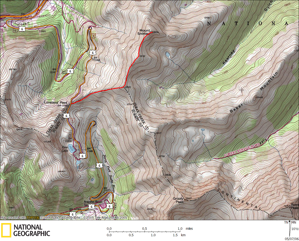
Mt. Sniktau is a rather unassuming peak not far from the Eisenhower Tunnel along I-70. The trail to climb it starts at the summit of Loveland Pass, meaning that you start your hike at about 12,000 feet, just above treeline. Last year, my friend Lonny and I had tried to tackle this peak as a warm up to the 14er season; however we quickly found that this ridgeline was prone to extremely high winds.
Of course, anyone who's skied at the Loveland Ski Area probably could've guessed this, but it didn't really occur to us when we hiked it the previous year. Last June, we were slow to get up the hill (it was the first peak of the year for us) and were battered by very high winds...if I had to guess, I'd say close to 80 MPH, but I can't be certain. We sat out the wind for awhile in a rock wind shelter before pressing on, but were soon enveloped in a high wind and gropple storm. We had some foul weather gear at the time (a must for Colorado hiking), but our rain shells could only provide so much protection. Most importantly, our eyes were stinging from the wind and all we had for protection was sunglasses. We turned back at the false summit and made it back to the wind shelter to wait out the storm for the better part of an hour, truly pinned down by conditions.
That was last year.
This year, learning from our mistakes (also hiking a month and a half earlier), we had ensured that we carried all the bad weather gear we could. Lonny and I had decided that we wanted to tackle this peak as a warm up for hiking later in the summer. As we drove up Loveland Pass, it was snowing, and there was a decent dusting of snow on the road. We had chosen to do this hike partially because we knew it was an "easy" 13er (since you start at 12,000 ft), but also because you hike along a ridgeline the entire time, meaning avalanche danger should be at a minimum. Both of us are cautious and respectful of avalanches, but neither of us are fully prepared for one, so our best (and only) defense is to avoid them (and the terrain that causes them) all together.

Since the weather was not great at the outset, we started hiking with nearly all our layers on. I had on long underwear under my nylon hiking pants (never wear cotton...it may be the fabric of our lives, but it sucks when it gets wet) and a few shirts layered on. At the trailhead, I threw on a pair of Gore-Tex rain pants, my soft shell, and then my rain shell over top of that, plus some gloves, a balaclava, a hat, and most importantly, a pair of ski goggles. The wind was already blowing fairly steady at the trailhead, so I was already appreciating the goggles to protect my eyes.
We departed the trailhead at about 8:30am. Climbing up the west-facing ridgeline, the snow was thin in most spots. In a few places there would be caches of snow that we would sink knee deep into, but overall you could pick through the small rocks up the ridge without trudging through snow. We had brought snowshoes with us on the hike, but we never took them off of our pack - the snow was rarely bad enough to justify strapping them on.

We followed the trail (or what we could see of it with the snow covering parts of it) up the ridge to a saddle where a few wind shelters had been built (one of which we took shelter in for an hour last year). It's about a mile from the trailhead and 1000 feet up to the saddle point (12,915 ft). From here, you can hang a right and tackle Grizzly Peak and follow the ridge up to Torreys Peak if you feel so inclined, however we went left instead and followed the ridge to Mt. Sniktau.
Now that we were up high along a dividing ridgeline, the winds were pretty steady - probably in the 30-40 MPH range now. Suffice it to say, goggles are an important accessory on this hike, even later in the year. We continued our ascent of the peak - we had learned last year that there is decidedly a false summit on Sniktau - in fact, there's an entire peak that you have to climb over and then descend before you reach Sniktau. On our ascent of the unnamed 13,125 foot peak, the snow coverage had gotten a little deeper (though still quite passable) and the talus had also gotten larger. This slowed our passage a bit, but we could still occasionally pick out a trail under the snow, and pick our way through the rocks until we reached the false summit.
Mt. Sniktau was now finally visible (for most of the hike, the actual peak isn't in view, just the false summit), however we had to descend down about 150 feet to the saddle before summiting. The talus again got larger, and descending proved rather slick. A large cornice on the eastern slope provided much easier passage, so we started hiking down along the top before deciding to glissade down instead. We were able to lose about 50 feet by glissading, then hiking along the hard packed snow the rest of the way to the saddle.

We began our final ascent along the same cornice, however some rocks about halfway up the peak would've forced us closer to the snow's edge than either of us wanted (we were hugging the rock-side of the snow shelf, figuring at least there was mountain underneath it if it gave way) so we picked our way into the rock field a bit more, making deliberate footsteps so as not to slip on the slick snow covered rocks.
We finally summited at about 11:00am - not the best time in the world, but given the snow coverage and the fact that this was our first peak for the season, it wasn't too bad. We hung out on the summit for about 20 minutes, snacking and snapping a few photos. The skies had cleared enough to show a little blue, but it was still fairly cold (about 20 degrees) and windy, so we didn't want to stop for too long.

Descending the rocks for awhile, we eventually got to the point where the snow shelf provided an easier walking trail again, so we glissaded down it a bit to the saddle, where we re-ascended the false summit. The snow shelf's snow was a bit softer here, and we tended to sink mid-calf deep, so I decided that the rocks provided a better climbing surface. At the top of the false summit, a backcountry skier was waiting for a few of his friends, as he was going to ski down the western face of Sniktau. He described the approximate route to us, but it was obvious he was going to have to descend a bit before finding skiable snow.
Returning to the saddle point was not too difficult, after which we began the final descent back to the car. The snow made the descent a bit slick, but not unmanageable. We returned to the trailhead at about 12:30pm.

All in all, this is a decent hike, and it could probably also be done in the dead of winter. I suppose it'd be interesting to see how easy or hard this trail would be without snow covering the majority of it. Since the trail was buried in snow, it became a Class 2 style hike for us, but not overly difficult, especially given its relatively short length and altitude gain.