San Luis Peak (14,014 ft)
We arrived at the trailhead around 5pm. There were two cars in the trailhead parking area and really only one flat-ish place to pitch a tent. The ground was pretty even everywhere, but sloped badly so it didn't seem an ideal spot to try to sleep.

We continued down the road another half mile and found the Skyline trail trailhead, which offered enough room to support 4 or 5 different camps. As we pulled in, another camper was packing up to head out. He was putting out his fire and offered the spot up to us, so we set up camp there.
Much to our chagrin, we quickly discovered that the previous camper did not seem to subscribe to the "leave no trace" philosophy. We found lots of small pieces of trash littered around camp and then discovered the mother lode: in the fire he was extinguishing was approximately 30 pounds of meat. Various cuts of meat: steak, ground beef, rib steak - all high quality. In addition to the meat, he'd also left a number of half empty cans of soda, corn, bottles (plastic and glass) in the fire. We started to pull the trash out of the fire and put it in our trash bag but realized that the meat would attract all sorts of unsavory animals we didn't want at camp. We stoked the fire up as hot as we could get it and positioned the meat into the coals to burn it.
At this point, you may be asking, "Gee - isn't this a San Luis trip report?" Well, yes - but this little camp escapade really aggravated us, so I just wanted to capture it somewhere. Okay...I'll get on with it.

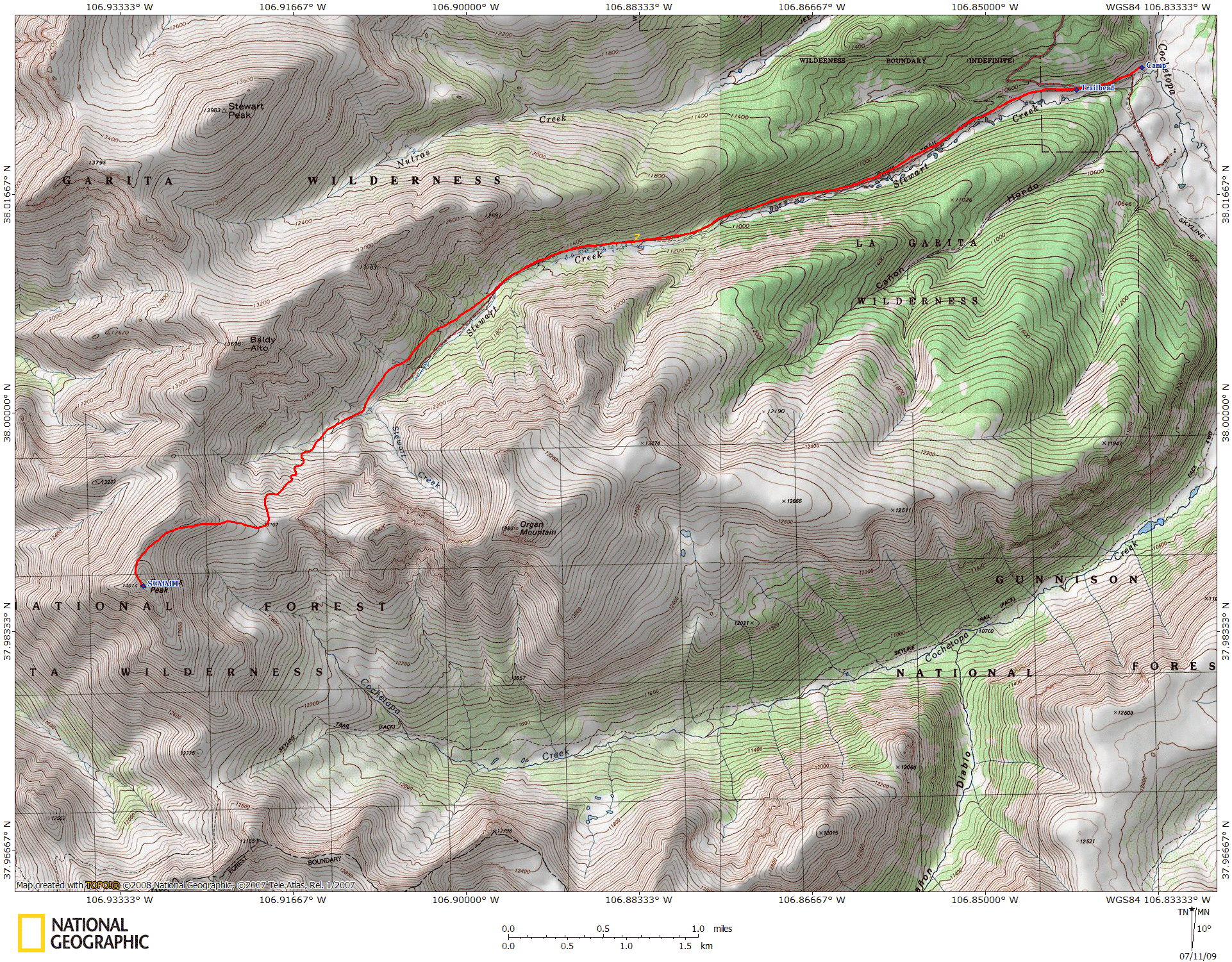
Lisa and I had decided to start the hike at 5am. With our headlamps, we hiked from our camp spot up to the trailhead and signed in (we hit the trailhead around 5:10am). Other campers at the trailhead were stirring, and according to the trail log, someone was already ahead of us on the trail.
The trail was super easy to follow in the dark, as it just gently crept up the valley floor. By 5:30, it was light enough that we didn't need the headlamps anymore. We kept looking over to our left at the riparian areas, trying to see beavers, moose, or anything else exciting, but we were sadly disappointed, seeing no wildlife other than birds and squirrels.
The trail was solid throughout the forest; however there were about 5 or 6 fallen trees that blocked the trail. In most cases, a path was worn around the obstacle, so it was not a big deal to get around them. There were two sets of log bridges across the stream, both were fairly slick with morning dew. The trail had a very gradual elevation gain for the first few miles. About a mile before exiting tree line, the trail began to climb up the valley wall quite steeply, offering the first real challenge of the hike.
 the prominent peak")
We saw no one else on the trail until we broke from treeline about 7:30am. At that point, we spotted two people far ahead of us beginning to ascend out of the valley. We spotted a large cairn on the other side of the creek about the same time we realized that our trail had ended, so we hopped over the creek on rocks and continued to follow the solid trail as it began to climb up the southern flank of the valley.
We were on top of the saddle between Organ Mountain and San Luis by 8:30am, about 3.5 hours from the trailhead. Below us in the valley, we could see additional hikers that were catching up to us, plus we were able to spot a few people on the summit of San Luis.

Continuing on, the trail became a bit rockier, but still very easy to follow. It wended its way up the ridgeline towards San Luis. Snow was not a problem on the trail at all - it had likely melted off the trail a week or two prior.
The push from the saddle to the summit was more work than the hike had been to that point, but the solid trail and frequent vantage points of the summit helped encourage us to the top. We reached the tiny summit at 9:30am and shared it with 6 other hikers. The view from the top made us realize how truly remote this peak was, as we could see no signs of civilization in any direction - not even the trailhead. Our ascent time was about 4 hours and 20 minutes from the trailhead.
After snacking and resting a bit, we began our descent at 10am. We noticed on our initial descent that the trail was a bit steeper than we had realized.

The trail was a bit slick on descent, as the angle and loose dirt made slipping pretty easy. Hiking poles and careful footing helped, and the slick spots were very short.
It took us about 45 minutes to return to the saddle, and we were back at treeline by about 11:30am. By this time the clouds had rolled in and our bluebird day turned overcast - we were happy to be in the trees. Once in the trees, we realized we still had about 3 miles left until we reached the trailhead, which made for a long afternoon. We passed a significant amount of hikers on our descent off the summit - Lisa counted 30 people total. This seemed like a lot of people to be climbing such a remote 14er, but it was the 4th of July.
We reached the trailhead at 1:40pm with little energy to spare. Camp was another 10 minutes past that, making our total hike time 8 hours and 50 minutes (8 hours and 30 minutes from the trailhead). A long hike for us, anyway.
San Luis was an enjoyable hike - the valley was quite green and the forest walk was pleasant. The only catch is its length. It's a long hike and you'll likely want it to be over long before you're back to the trailhead. Thankfully, most of the elevation descent occurs early on, and the last 3 miles of the hike are relatively flat, sparing your knees some agony (but not your feet).