Mt. Massive via the Southeast Ridge (14,421 ft)
After hiking more than 120 miles so far this year (!), I decided I may never be in this good a shape ever again, so I called my buddy Lonny and asked if he wanted to take a day off to tackle Mt. Massive. He'd tried it a few weeks before via the Southwest Slopes route and didn't succeed, partially due to weather and just the cruddy condition of the "trail" (he said that in each step, he slid so much in the scree that he made nearly no progress).
Mt. Massive, of course, is massive. It's the second tallest mountain in the state, topped only by its neighbor, Mt. Elbert. When Lonny and I did Elbert last year, we got up early and drove from Denver to the trailhead in the morning, hitting the trail maybe at 7:30am. Since Massive was a long hike no matter which way you slice it, we decided it was in our best interest to get a really early start, so we stayed in Leadville the night before.
It's not that I'm entirely against camping, it's just that before tackling a long mountain, I'd rather have a warm bed then a cold sleeping bag and a tent; given the choice, of course. So, the Super 8 was our base camp - not a bad place to stay in Leadville. The alarm went off at 4:00am and we struggled to wake up. As we loaded gear into the car, the sky lit up with lightning and we could hear thunder not too far away. This didn't bode well for us; there was a nearby electrical storm and we hadn't even hit the trail yet.

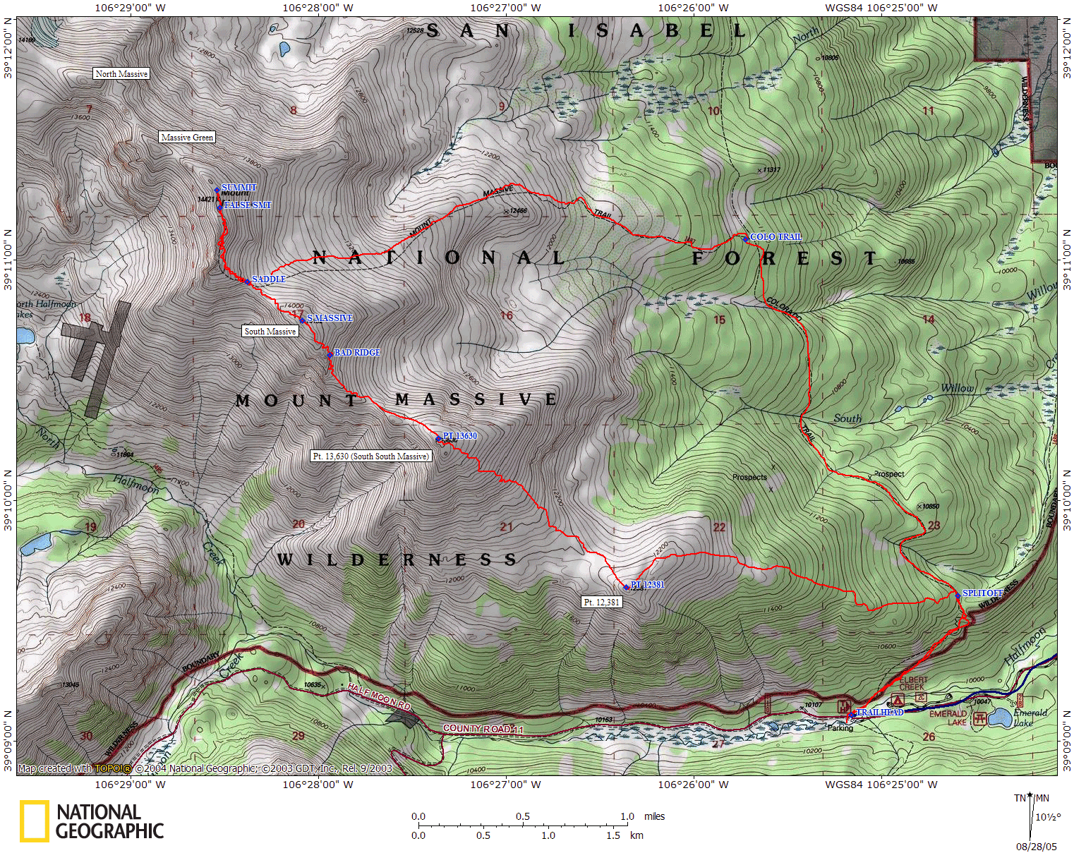
From the hotel, it took us about 30 minutes to reach the Mt. Massive. We'd decided to either climb the standard Mt. Massive trail (which followed the Colorado Trail for quite a bit) or, if we were feeling particularly masochistic, try the Southeast Ridge route described in Roach's book. Despite the Southwest Slopes route being shorter, after Lonny and another friend's experience, it didn't sound appealing, and Lonny had no desire to go after that route again.
The trailhead for either route was Mt. Massive Trailhead, just passed the Halfmoon Creek trailhead for Mt. Elbert. We arrived around 5:30am in a pouring rain/hail mix. The lightning was still not abating, but as we got our gear on the rain let up quite a bit. We decided that we still had a long way to tree line, and we could hike and see what happened to the storm once the sun came up.

Headlamps on, we filled out a free wilderness permit at the trailhead and set off just before 6 am. The trail had a pleasant gentle grade to it that was illuminated by our headlamps. By 6:20, we no longer heard any thunder, and daylight was starting to break. We shot a few photos of the fog that was slowly creeping up the hill and shed a few layers. Roach's book indicated that we followed the trail for a mile, and departed at about 10,800 ft. My GPS was having a touch time getting a signal in the forest, but the altimeter was working fine, so at 10,800 ft, we left the trail (at 6:30). There was a small rock cairn visible at the departure point (that we didn't see until our descent), but other than that, there's no real indication of where to leave. The idea was to follow the gentle ridge up to tree line, this ridge, however, was a bit ill defined at the lower elevation. Checking the GPS every so often to ensure we were heading the right way, eventually the ridgeline was more obvious as we rose higher. We emerged from the trees into the "petite parlor" that Roach described around 7:30am and now continued on more grassy slopes. Once we were within about a quarter-mile away from Point 12,381 did we finally see it, and the next milestone: Point 13,630. Up until now, we really couldn't tell what direction we were to head in without looking at the GPS. The summit of Point 12,381 provided a nice view of Elbert as we crested it at 8am.
 from Pt. 12,381")
Point 13,630, or South South Massive, looked rather daunting. Rising about 1400 feet above the saddle in a mile, the grassy slopes were steep and dusted with the snow/hail that fell as we drove to the trailhead. The 30% grade was abusive! There were scant traces of a trail worn into the hillside, and we occasionally followed them when they appeared, but as quickly as they appeared, they disappeared again, at which point we dispersed as to not erode the tundra as much. It took us about an hour and a half to top out on South South Massive - a slow push, but given the steepness, not a bad pace. On the top, we snacked for a bit and contemplated our next push up to South Massive at 14,132 feet.
We had to drop about 270 feet down to the saddle, which was made a little challenging by the snow covered tundra and wet rock (lots of slipping), but it was nothing compared to what lay ahead for us. Roach's book doesn't say much about this particular slope, other than it is a "rougher ridge." That's an understatement! There looked to be a solid rocky outcrop along the top of the ridge, and scree down below. The top of the ridge looked to Class 3-ish that we didn't want to attempt (as the hillside fell away quickly down the southwest side of the peak, and we don't care for exposure so much), so we picked a route that wended its way through the solid looking rock. I emphasize "solid looking." As we entered the rocks, what appeared solid from farther away was really incredibly loose talus and scree, moving under each footstep. Since we were traversing the slope, it made for very awkward footing, and with each step we weren't sure if we might trigger a rockslide above us.
 from Pt. 13,630")
After a few hundred feet of this, we decided it was better to fight the scree than to try to traverse the loose talus, as the scree we could ascend directly. Dropping down below the rocks, we hit the large scree field, where the small and medium sized rock sat on sandy soil that gave way just as easily under foot. At one point, I took about 6 steps and actually got nowhere. My trekking poles were probably the most useful they've ever been in this stuff!
Each step was a challenge. I would go ahead, gain a few feet and find a stable footing, then Lonny would follow, so we avoided the very real risk of knocking large rocks down on each other. Finally, we cleared the worst of the scree and got footing on some stable rock. We took a break about 100 feet below the summit, where the rock was stable; it had taken us a little over 2 hours to cover this stretch of 800 vertical feet! This was by far the most wearing part of the hike, and we didn't particularly enjoy it. Perhaps had we gone up on the top of the ridge it would've been easier, although it certainly didn't appear as though it was any more solid up there.
We summited South Massive at about 11:40. This entire time, we were watching the clouds to see what they were going to do. They didn't look great, but they didn't look bad yet. We decided that the clouds looked non-threatening enough to press on, so we continued down to the saddle between Massive and South Massive. We finally saw hikers ascending up towards the summit - the first people we'd seen all day. We started up the climbers trail that switchbacked through the rocks. It was nice to have a trail to follow finally, however it meandered and split dozens of time on the hike up, forcing us to choose which route to follow, often doubling back a bit if we chose the wrong way.

The trail we ended up choosing took us up over the top of the numerous mini-summits near the actual Massive summit, providing some great views of the surrounding area. Once past the largest false-summit, the real summit was obvious only because a hiker ahead of us was holding up the summit log canister (otherwise I wouldn't have known that it was the actual summit).
We hit the summit at about 12:45pm. The clouds, thankfully, had opened up directly above the peak, and we had continuous sun for a good bit of time, allowing us the nicety of relaxing a while on the summit, something that I didn't have the luxury of doing on top of Mt. Shavano, my previous peak. We took photos, ate food, and chatted with the four other people that were up there - one person had only 7 peaks left to finish all 53 14ers in the state!
For such a large mountain, the Mt. Massive summit is actually very small. Just a pile of talus, really. There's plenty of room on the surrounding ridge, but it drops rather dramatically to the west, and a little more gradual to the east. From here, you could clearly see Mount of the Holy Cross, Snowmass Mountain, Capitol and Pyramid Peak, the Maroon Bells, Elbert (obviously) and a few of the Collegiate Peaks, as well as Sherman, Democrat, and Quandary - just a few!

At 1:20, we left the summit and returned to the saddle by about 2:00pm. We had decided that if we were to do the Southeast Ridge approach, we'd simply take the longer Mt. Massive trail down, as there was simply no reason to punish ourselves more, and it offered a nice loop. We started down the solid trail which had a nice gentle grade to it. The trail wended its way down over the green tundra, eventually dropping down close to treeline into some willows. Here, we could look back and see all four peaks that we had tackled - it was quite something to see. We hit treeline around 3:30pm, moving at a pretty good clip as the trail was very solid and well maintained. We stopped a few times to rest our feet a little, as we still had a few miles left to go. Once we hit the Colorado Trail, the trail leveled out quite a bit and became quite pleasant. Flat and wide, we made a pretty good pace over this portion, reaching our splitoff point from the morning around 5:00pm. Half an hour before, we finally heard some thunder in the distance - the afternoon storms were finally materializing that we had feared hours before.
We returned to the trailhead at 5:45pm - just about 12 hours round trip. The Mt. Massive trail was long, but rather gentle. I'm guessing we would've made much better time had we taken it on the ascent too, as we lost a lot of time on South Massive, but we did a rather grand tour loop of the southern side of the mountain, and enjoyed it thoroughly.
I wouldn't strongly recommend the Southeast Ridge route, simply because South Massive was so cruddy to climb. As I said, the very top of the rock ridge may be more stable, but I doubt it. It was a pretty approach, but grueling. If you chose this route (well, actually, any route on this mountain), start early!