Margy's Hut
With a large degree of trepidation, my wife and I committed to join what was being affectionately referred to as the "march of death" - at the time, it was an 8 mile hike with 3000 feet of elevation gain to Margy's Hut (A 10th Mountain Division Hut) from the Norrie trailhead.

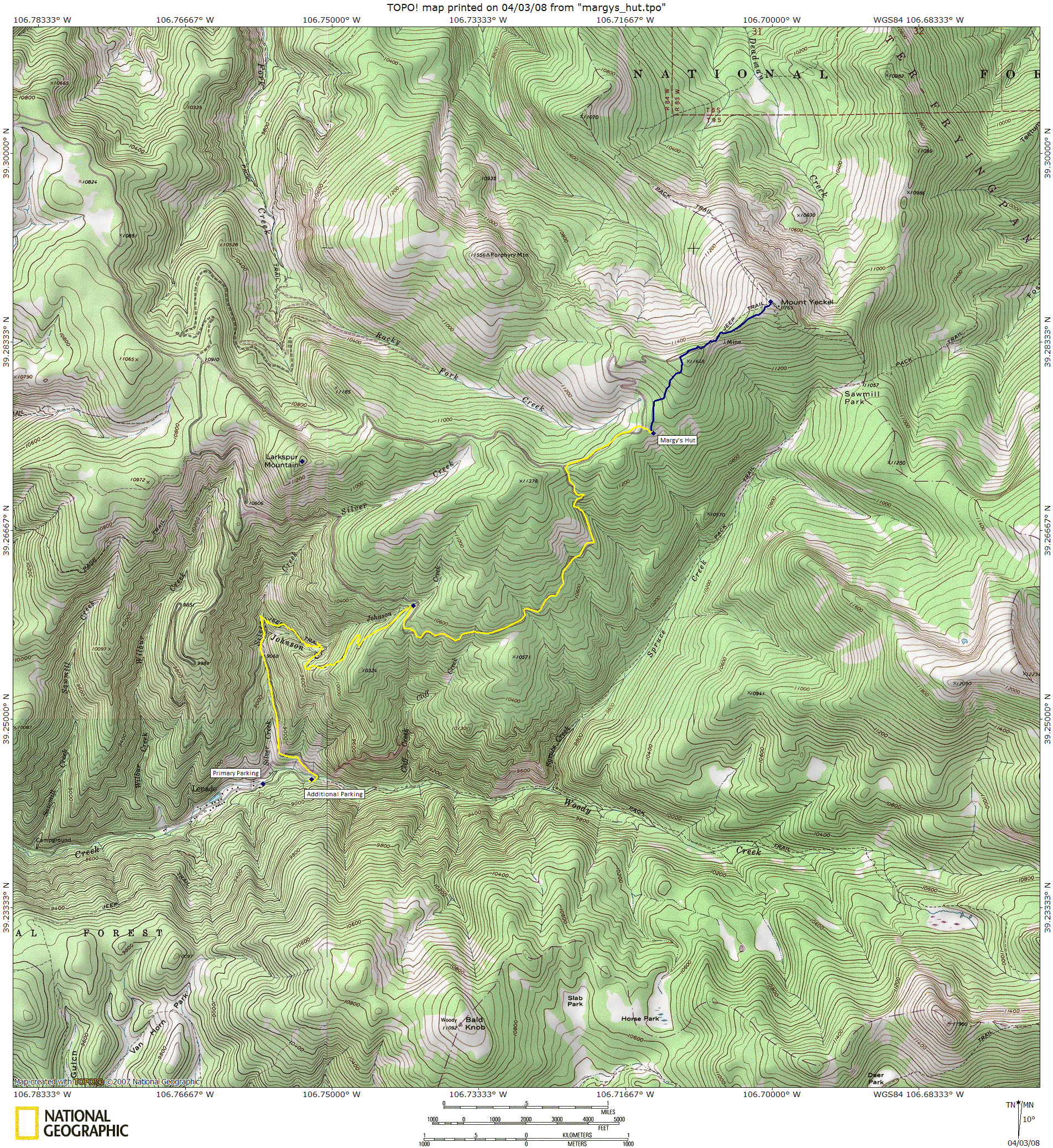
A group of co-workers had done these hut trips for the past 8 years, and assured us we'd have a great time - which we did - but the distance was certainly intimidating. Due to trailhead access issues, we instead hiked in from the Lenado trailhead, shaving about a mile from the overall hike, and 200 feet of elevation yielding a 6.8 mile, 2800 foot hike. Even on dry land without snowshoes, this would be a challenging hike - with snowshoes and a pack, it posed a significant challenge. Arguably, this is probably the second most challenging hike in the 10th Mountain Division hut system (the hardest is Skinner Hut). Of course, we'd been planning this trip for over a year, since Tory had drawn this hut in the previous year's lottery, and we'd all resolved to train hard...none of us did.
All 14 of us met in Glenwood Springs the night before and stayed in the Comfort Inn so we could get an early start the next morning. Out of our group, about 6 of us (including Lisa and I) had never been to a hut before. A few, like Tory and Doug, had been doing this for 8 years straight now. This expertise helped tremendously in preparing for the trip - what to pack, what not to pack, and what food to bring. Our packs were lighter than they would be if we were backpacking (no tent, pad, stoves, etc.) but what we lacked in gear we made up for in food (and liquor: 30 oz of Brandy, 6 liters of wine, and enough margaritas for all!)
For more information about the hut, check out these links: HutSki.com or Huts.org
Day 1: Saturday, March 8, 2008
From Glenwood Springs, It took about an hour to reach the trailhead, which was between Aspen and Carbondale. The road was well plowed to the hut parking area, but the parking area posed a challenge. Between the 14 of us, we had 5 cars loaded with people and gear. The parking area (at least the are that was plowed

- with 5 foot walls of snow) could hold 4 cars before you started blocking people in - of course, we could all block each other in as we would all leave at the same time, but there were two cars already parked in the lot. We creatively crammed 4 vehicles in, allowing enough room for the two other cars to back out when they returned, but our car wouldn't fit. We drove up the road another half mile and found a spot that did not appear to have any parking restrictions, so we parked there (when we returned, we saw a 10th Mountain Division Hut Association truck parked in front of us, so I figure where we parked was probably fine).
By the time we sorted out the parking situation, got our gear on, and were ready to hit the trail, it was about 10:00am. As we rounded the corner on the trail, we saw about 50 snowmobiles idling in a clearing alongside the road - apparently this is the launching point for a commercial snowmobiling operation. As we hiked up the road, about a dozen snowmobiles passed us as a wave of tourists headed off for their mechanized fun - thankfully at a gentle speed and a wide berth. A mile from our starting point (and perhaps a mile and a half from the parking lot), the trail broke from the well groomed road, and any trace of snowmobiles. Nearly everyone threw on their snowshoes at this point.

As the trail broke from the road, the grade increased significantly. Between the trail pitch and our snowshoes, our pace slowed significantly. Aspen and spruce trees surrounded the trail, but as we ascended, we could obtain occasional glances of the Aspen ski area; that is, when the weather cooperated (it was snowing on and off the entire day). There was a little trail breaking that had to occur, as there was about 4 inches of fresh powder on the trail, however a well-worn path was already present, making travel a little easier.
At about 12:20pm, we reached the trails' intersection with the road again, marking the end of the steepest portion of the hike. We were essentially at the half-way point - 3 miles in and 1700 feet gained. Half of the group (the fast half) was already waiting at the junction, eating lunch, so we joined them. After a brief lunch, we pressed on, relishing the new-found flatness of the terrain. To this point, the average grade was 12%, the remaining grade only 8% - of course, we still had 3 miles to go.
We plodded along the trail for another 2 hours, steadily ascending towards the ridge crest. The clouds and snow had closed in, so the views were non-existent. Eventually the trail leveled off at 5.3 miles (2:40pm), reaching the crest of the ridge (intersecting Larkspur Mountain Road - obviously not used as a road in the winter). Despite the level terrain, we plodded along slowly - Lisa and I were exhausted.
Twenty minutes later, we reached a clearing in the woods where the trail drifted to the right. Through a small break in the trees, I finally saw a most glorious sight: the hut! We arrived shortly after 3:00pm - the faster hikers made it in about 15 minutes before us. All in all, it was a grueling 5 hour hike in, but

we made pretty decent time. The benefit of arriving at the hut first is first choice of beds - the benefit of arriving last is that the fire is already going and the hut is nice and toasty! Besides, I had been relegated to the bedroom downstairs: the snoring room.
Everyone was beat from the hike and was thrilled to be able to just sit back by the fire and relax. As the snow continued to fall, we spent the next few hours doing absolutely nothing - and loving it! This was the time for those heavy packs to pay off: food! Dinner on Saturday was salad, spaghetti, sausage, garlic bread and 6 liters of wine, finished off with snow ice cream (sweetened condensed milk combined with snow...and blueberries). Never has food tasted so good!
Day 2: Sunday, March 9, 2008
 and the Elk Mountains at sunrise")
I awoke before the sun rose on Sunday morning. It was a clear morning, which revealed an absolutely spectacular view to the south. From the warmth of the hut, we had front row seats to a beautiful sunrise over the Williams Mountains. Walking just outside the hut and to the west a few feet, a small portion of the Elk Range (with Castle Peak dominating the view) were reflecting the pink alpenglow of the morning sun. As the sun rose, more of my hut-mates woke up and started to peak outside at the clear morning sky. The agenda for Sunday was light - group breakfast, our own lunch, and a group dinner - anything else was up to us.
Breakfast was prepared by Tory and Brian Coover: blueberry pancakes, sausage, and scrambled eggs. Coffee was provided by Roy's French press (however it appeared that the hut actually had a stovetop coffee maker there). After breakfast and cleanup, the hut started to plan what was next. Brian Coover

brought a sled with the intention of finding a good sledding hill nearby, and most of the hut decided that sounded like fun. Tory, Roy, Jay, Lonny, Robyn, Howard, Carlos, and I decided to hike Mt. Yeckel, the 11,400 ft mountain that we sat on the slopes of. A few others decided simply to hang back at the hut and do nothing - another admirable choice given the soreness everyone felt.
Heading northeast, the summit of Yeckel was not far above us, but still not visible. The trail on the map showed a winding 2 mile route following a 4WD road, but a pre-broken trail seemed to shortcut straight up the hillside. This trail shortened the route to 1.25 miles, one way. Eventually, we reached the summit of a shorter (11,648ft) peak along the connecting ridge. Tory and I continued on to the summit of Yeckel (despite the fact that Robyn and Lonny contend that they were on the real summit). We dropped down into a connecting saddle and a few minutes later arrived at the summit of Mt. Yeckel. The summit was just at treeline, so the trees were sparse, yielding a fantastic unobstructed view in all directions. The entire Elk range was visible, as were all 4 Aspen mountains, the Williams Mountains, and the back side of the northern Sawatch range (Mt. of the Holy Cross). I highly recommend this hike if you plan on spending time at Margy's!

We arrived back at the hut and had lunch. There was still a lot of wine left from the night before (and we didn't want to pack it out or dump it) so we most of us spent the afternoon playing Scrabble, Euchre, reading, and drinking wine. Dinner on Sunday was Carne Adovada, rice, beans, and margaritas, with pudding as dessert.

Day 3: Saturday, July 30, 2005
Monday morning we awoke to more cloudy skies, obscuring the beautiful views we'd had the day before. We hit the trail around 9:30am after packing up our stuff and cleaning the hut. The descent was far more pleasant than the ascent, however the overcast skies kept the views hidden once again. By 10:30am, we were at half-way point where the trail branched off from the road once again and

the descent became steeper. The skies started to clear a little, yielding views of Aspen's Ajax mountain through the trees. We reached the trail and groomed road junction by 11:20am where we removed our snowshoes, reaching our cars by noon. We ate lunch in Glenwood, and some of us decided to take a dip in the hot springs before returning home to Denver - well worth it!
All in all, the entire hut experience was fantastic - we had a great group to hike with that were a lot of fun to be around, the hut itself was awesome, and the views were terrific. The worst part, by far, was the hike...I would say it was as or more difficult than the ascent out of the Grand Canyon that we'd done last November (of course, that was from 2,000 to 7,000 feet without snowshoes). That said, we weren't in terrific shape, and if we could do it, I'm sure most people could. Traveling with experienced hut-ers helped quite a bit - they knew what to expect and how to eat well in the hut - I recommend you do the same if you go!