James Peak (13,294 ft)

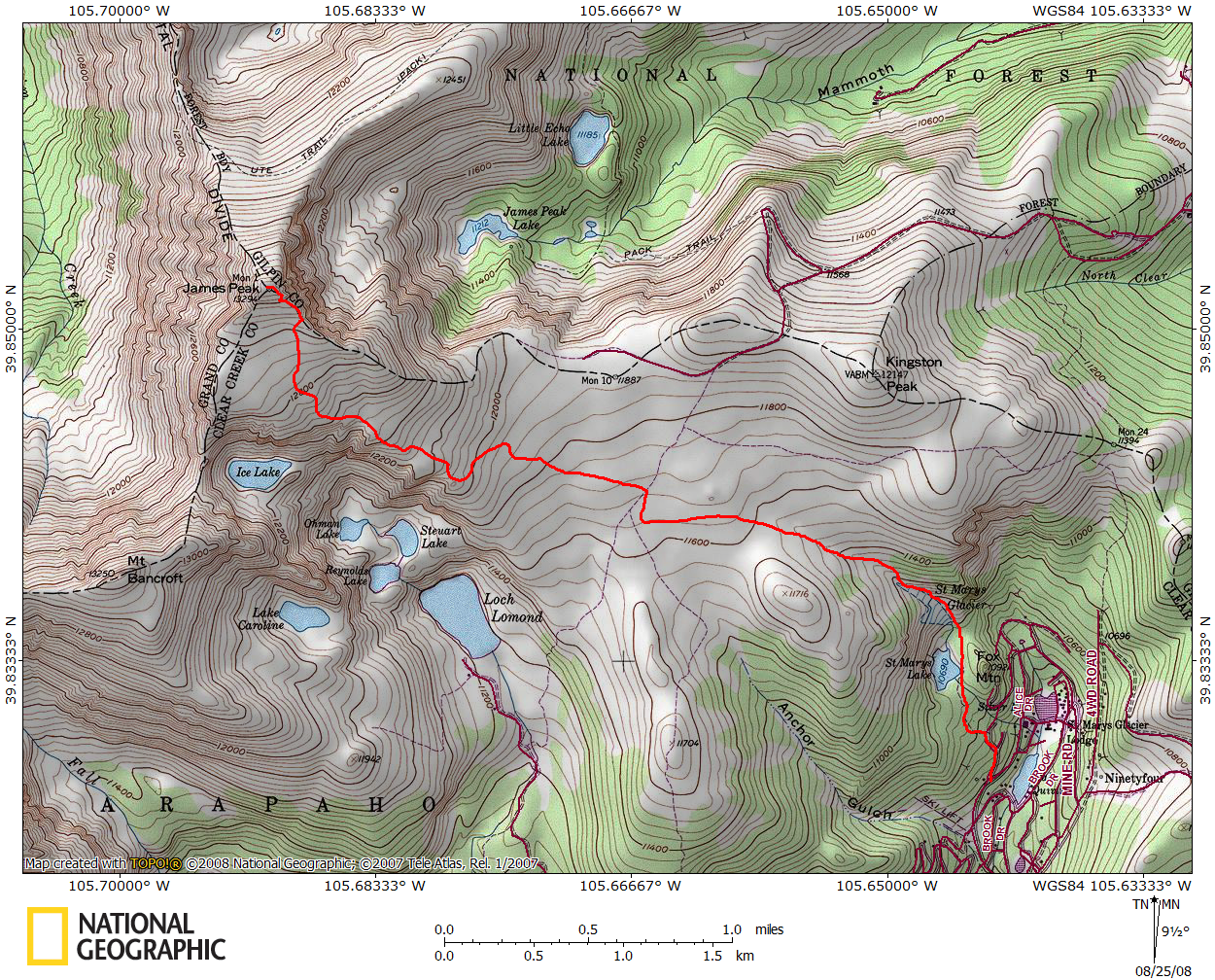
I've been eyeing James Peak for years now - both from the front range and from Winter Park, so on an early Sunday morning, I decided to tackle it. Based on my available vehicle (a sedan) decided not to try the Loch Lomond approach, and opted for the paved and smooth ride up to St. Mary's Glacier. As some guidebooks have pointed out, parking is a bit sparse. Thankfully, at 6:00am, there were only three other cars on the side of the road (camping, I suppose) - this worked well, because it looked like you could fit maybe five cars on the shoulder - tops (at least that's what I thought until I returned to the car later). An entrepreneur up the road was charging $5 to park in a small parking area...but who knows if he was there at 6am.
Ascending towards St. Mary's Glacier was not quite as straightforward as I expected. The trail was basically a rough 4WD road, however it forked a few times. I think in general, I took the left path and it got me there fine. The "glacier" and lake was deserted when I arrived at 6:45 as I started my ascent up the right-hand side.

It was slow-going - the snow was pretty solid, providing a good climbing surface, and my hiking poles helped provide a bit of stability. Eventually, a trail started peaking in and out of the left side of the glacier, so I made my way over to it. It disappeared under the snow a few times, but soon enough I was off the snow and making faster progress on dry land.
The climb leveled off, and James Peak was straight ahead of me. The trail was pretty solid and led across the large alpine meadow below the peak itself. Eventually, I ran smack into a perpendicular 4WD road. At this point, all the maps I'd reviewed before the trip indicated just to keep plowing on across the meadow, trail-less; instead, I followed the road north a ways to see if a trail broke off. I spotted a large cairn on the west side of the road, but no semblance of a trail anywhere. After a few hundred yards, I realized that no trail was to be had, so I broke off from the road and headed towards the peak across the meadow. The meadow was a breeze to hike through - relatively flat and even, with only a few ankle-high willows to traipse through.
As the peak ascended above the meadow, I could see a few 4WD roads criss-crossing the mountain. I decided that following an old road would be a bit more pleasant than a full-on attack of the slope, so I angled my way towards one of the lower roads. As I ascended the road, I spotted three other hikers about half a mile south of me on what appeared to be a trail! They were coming up from Loch Lomond, which apparently had a much more solid trail. The road proved to be a decent trail, and eventually it intersected the trail that the other hikers were on. Once that occurred, I broke from the road to follow the well cairned trail, which switchbacked nicely up the mountain to the summit. I spotted two hikers on the summit already, leaving the grand total of hikers I'd seen to 5 (plus marmots, pikas, and some elk).

I reached the summit at 9:15, about 2 hours and 45 minutes of ascent. From the top, I had a clear view of the Frasier river valley, including the Winter Park/Mary Jane ski area; Rollins Pass, Longs Peak, Grays and Torreys, Evans and Bierstadt, and even Mt. of the Holy Cross. I could hear the fans of Moffat Tunnel far below, although I couldn't see either portal.

The day was a warm one, and there was only a slight breeze on the summit (usually the continental divide is pretty windy), so I relaxed on the summit for awhile, talking to the other hikers that came up behind me.
I started my descent around 10:05am, and stuck to the trail, rather than breaking off on the road on which I ascended. The trail was well cairned and solid in most sections, but there were times that it nearly disappeared into the tundra. Back down in the lower meadow, the 3 other hikers pointed out to me some small blue flags which indicated where a future trail would go, but didn't exist yet. I broke from the trail and back onto the tundra, following any sign of the blue flag I could find (I saw a total of 2 in half a mile). But, staying on that bearing, I ran right into the 4WD road again - exactly where the mysterious cairn was that I saw before. So, the lesson here, is that as you're ascending, depart the road at this cairn, and head west north west (282 deg) and eventually you'll intersect a nice trail which will take you all the way to the top.
My morning of solitude was over, as I spotted three jeeps driving up and down the 4WD road. I headed down the road one tenth of a mile until I saw the other pile of cairns indicating where I picked up the remainder of the trail. It gently descended down to the top of the glacier, at which point I donned a pair of rain pants and gloves. I hiked down a good portion of the glacier, but once it got a bit steeper, took advantage of gravity and glissaded down. The snow was pretty dirty, but it made for a fun descent. Of course, the solitude at the lake was gone too, as there were probably three dozen people scattered all over, enjoying the snow and the water. I continued to descend down the 4WD road, passing a dozen more people ascending to see the glacier, finally making it back to the car at 11:45am. Shockingly, the street was lined with vehicles parked on the side (where there wasn't much of a shoulder, so they were more on the road than anything else), and $5 guy's lot was completely full. I have no doubt that a minute after I pulled out of my space, it was taken!
James Peak was a delightful hike - even with a broken trail, it was not too difficult, and offered some great views from the summit. Once you're past the glacier, the crowds were non-existent, giving you a nice quiet hike (at least until the jeeps show up, but that's just a small section of trail).