Huron Peak (14,003 ft)

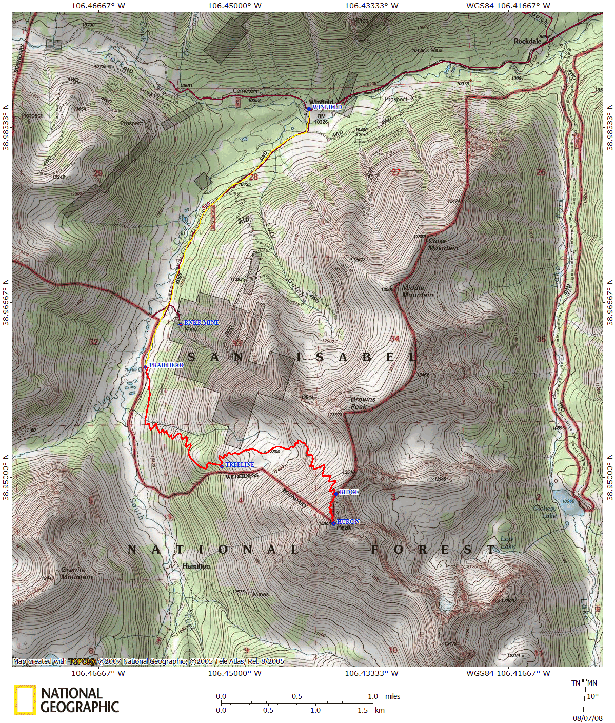
After climbing Belford and Oxford in one trip and Missouri in another, I was become relatively familiar with County Road 390 which takes you back to Vicksburg (trailhead for Belford and Oxford), Rockdale (the trailhead we used for Missouri which takes you Clohesy Lake on a rough 4WD road), and Winfield, the turn off point for the Huron trailhead. With our 4Runner, we drove up to the trailhead, just passed the Banker Mine. The road was relatively benign for a 4WD road - bumpy, sure, but no death defying maneuvers were required. I would've said that the drive required 4WD and high clearance, but we did spot a Subaru Outback at the trailhead, which has slightly lower clearance.
We started our ascent at about 7:20am - In counting the people that we passed (coming down) as we went up, Lisa figured out that we were 13th on the mountain that morning. The trail switchbacked gently up through the

forest, providing fantastic glimpses of the Three Apostles and Huron. We reached treeline around 8:30, which opened into a nice high-alpine meadow below the summits of Huron and Browns Peak. Of course, we'd wasted precious mileage on switchbacks and meadows, and now the trail came to exact its revenge. A long series of steps climbed up and around a cliffy-like section, making the ascent as pleasant as possible. We ascended the steps slowly, spotting pikas darting in between the rocks and admiring the tarn in the meadow below. Once out of the steps, the trail lapsed back into switchbacks that cut through the grassy hillside. The angle of ascent was fairly constant, so as long as we kept a steady pace the climb was manageable. (Kudos to the Colorado Fourteeners Initiative on their superb trail!)
At 9:30, we reached the ridgeline of Huron, offering a fantastic view Missouri, Belford, and Harvard. The

trail conditions changed at this point - the grassy slopes finally gave way to talus, and the trail, although still very solid and easy to find, became a little tougher. The trail ascended steeply through talus and slick dirt - poles helped tremendously here, as the soil behaved a bit like ball bearings (more so on descent). From the ridgeline to the summit was about 500 feet, and the trail length was just under a quarter mile, giving you a grade of about 37%!
The push to the summit was short and sweet, as it only took about 20 minutes of climbing before you were there - and the push was worth it. The view from Huron is undoubtedly one of the best from the Sawatch range. Not only does the summit provide a view of about a dozen other 14ers (more on a clear day), but also fantastic views of some other peaks, like the Three Apostles. Basically, the only civilization that can be seen from the top was Taylor Park (and that's hardly a bustling metropolis). Huron's summit is made even more dramatic

by its small size, yielding impressive views at every angle. Thankfully, we were on the top with only 5 other people...a little later in the day and it would've gotten a bit crowded! Our ascent had taken about 2 hours and 40 minutes.
We lingered on the summit for about an hour, as the weather was absolutely wonderful. As we descended, it was clear as we descended that we were certainly earlier hikers than most - about 40 people could be seen spread out on the slopes below us (a far cry from Grays and Torreys, but still a good number of people). Descending the talus slope proved to be a bit more challenging than ascending, and again, the poles helped. After about 20 minutes, we were back on the grassy slopes again, switchbacking back down the mountain. It took us about an hour to reach the flat meadow just above treeline, and about another hour to make it from treeline back down to the car, making our descent about 2 hours.

Huron was a very pleasant peak. The hike is short and steep, but it's over with pretty quick; the solid trail made it very nice, requiring no real route-finding skills. Huron has now become my second favorite peak (second to Handies in the San Juans).