Mount of the Holy Cross (14,005 ft)
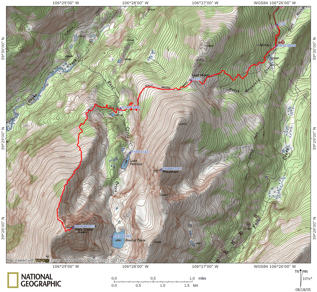
My friend Shari Post had recommended this trip last year, but we ran short on time, so we decided to do it over the 4th of July weekend. The hike starts near Vail (Minturn, actually) and requires you to gain about 1400 feet over Half Moon Pass, and then drop 1000 feet down into the valley. Since that's a lot of effort on top of a 4000 foot elevation gain, we decided to camp for two nights in the valley.
Day 1: Saturday, July 2, 2005
We drove up on Saturday morning (July 2nd), arriving at the trailhead shortly after noon. The approach road wasn't too bad, but it was nice to be in a more rugged vehicle (Brad's Land Cruiser) rather than a low sedan. The trailhead parking was jam packed, and we parked back about ½ a mile along the road.

Gathering our packs and gear, we set out, filling out a (free) wilderness permit at the trailhead along the way. The trail gradually ascended through a nice forest, though we quickly realized that the mosquitoes here were merciless. We stopped for lunch around 1:00pm and coated ourselves in bug spray.
We crested the top of the pass at about 2:00pm, which is about 11,600 ft (and pretty much the top of treeline). As if on queue, just as we were cresting the pass, a burst of lightning immediately followed by thunder occurred. Thankfully, we weren't too far from treeline, so we darted down the trail another few hundred yards into the (relative) safety of the nearby trees. There were perhaps three or four other strikes of lightning, farther away, and the storm dissipated; leaving us with a nice sunny afternoon. We'd only seen a few people on the trail so far, but on the other side of the pass, we passed maybe a dozen people hiking out.

The panoramic views started to open up to us, until we rounded a corner around 2:30pm and finally caught sight of Mount of the Holy Cross for the first time - it was spectacular! It shot up from the valley floor nearly 2000 feet below and simply looked amazing. We quickly hit a series of switchbacks with a nice sheer drop to the side down into the valley below (a little too sheer, if you ask me). We had about 2-3 miles of ascent of 1400 feet on the east side of the pass; we lost nearly 1000 feet in little over ¼ mile on the other side!

The switchbacks dropped us down quickly to East Cross Creek, where we were able to cross (very carefully) on a series of rocks and logs. Once we reached the other side of the creek, we struggled to find a campsite. There were plenty of fantastic locations, but they were all too close to the stream. Eventually, after meandering up the trail a little further and wandering on some social trail, we located a site at 39°29.335'N, 106°28.215'W at 10,700 feet, nestled in between some giant boulders. We saw maybe four other tents, including one belonging to a Forest Ranger in the area.

We'd hiked about 4.5 miles on Saturday, meaning we had just about 2 miles left to the summit. The only problem was that the summit was about 3,300 feet above us! We set up camp around 4:00pm that evening, and roasted marshmallows over a camp stove (since we'd thought there was no fire ban according to the Forest Service's website, but signs at the trailhead indicated otherwise). The sheer number of mosquitoes we encountered was ridiculous. Brad managed to kill over 100 in less than an half an hour (before he stopped counting). If you do this hike, bring bug repellent!
Day 2: Sunday, July 3, 2005
Sunday, we all awoke around 7:00am, had a leisurely breakfast, and started on the trail a little after 8, after seeing a handful of other hiking groups passing by our campsite. As we ascended the trail through the forest, we saw maybe four more tents along the way, so there were certainly a few more sites available beyond where we had picked (but they were farther from the only water source: East Cross Creek).
We broke out of the trees shortly after 9:00am. This was our first fourteener of the season, and it was not a gentle warm up. Lonny was struggling for the first hour or so of the hike, and Shari and I were proceeding slowly (meanwhile, Lisa had a decent pace and kept pushing up the slope).

By 10:00am (at around 12,500 feet), the trail pretty much disappeared, and we were forced to scramble over sizable boulders. This made for slow going for most of us. Lonny had begun to feel better (after eating), but I started to feel worse. We were slow to get through the lower portion of the boulder field, scrambling along the eastern edge of the mountain, where some large cairns indicated the trail went (not that we ever found one). To the west, large snowfields still covered a lot of the hillside, covering what may have been a real trail through this section.

By 11:00am, we hit a small reprieve in the climb, the first semi-level pitch we'd seen. We were at about 13,000 feet, with still another 1000 feet left. The boulders didn't stop anytime soon, but someone descending had recommended that we hike along a cornice overhanging the eastern face. The snow was solid, and still over rock, so most of us hiked over it, which was a nice break from slogging over boulders.

Our hike reprieve was over, and we hit the last 1000 foot push up the back side of Holy Cross (with a quick glance down Angelica couloir). Again, the boulder field was a pain, but Brad and Lisa were making light work of it. Lonny, Shari, and I were all making slow progress up through the rocks (you know how it is, "Hey, I found a trail...wait...no, never mind....stay where you're at").
At 12:20pm, we finally made the summit (Brad and Lisa made it about 10 minutes earlier). We took a long break, and enjoyed the view with the dozen other people up on top. A lot of snow was still present near the eastern face of the peak, so we didn't wander around much. The view was fantastic, with Mt. Elbert, Mt. Massive, Climax Mine, Vail, Notch Mountain, and the Gore Range clearly visible, not to mention Snowmass Mountain (which we hiked around in August).

After eating at the top, my energy finally returned, and I felt much better. Around 1:00pm we started our descent, as puffy clouds were beginning to fill the sky and we didn't want to linger too long. The ascent really took its toll on us, and we were pretty tired when we started down. Brad decided to take this opportunity to glissade down some of the sizable snowfields we'd avoided while climbing. Eventually, all of us were glissading down some of the snowfields, losing as much as 200 feet of elevation in a minute or so. Of course, rocks pose a bit of a hazard (Lisa tore her pants a little), the glissade wasn't too bad (except that our pants were soaked afterwards, as we didn't have snow gear).

We arrived back at camp around 3:30pm, thoroughly exhausted. Despite the fact that we had traveled little over 5 miles in total, we had gained and lost 3,200 feet in that short distance. Rain had held off much of the afternoon, but it finally arrived around 5:00pm and continued lightly for an hour or two.
Day 3: Monday, July 4, 2005
Again waking around 7am, we had a nice leisurely breakfast of pancakes and bacon (courtesy of Shari and Brad), and headed out around 9:15am. Despite the pain that the pass had caused me on Saturday, I had two grueling days of hiking under my belt, and the re-ascent of the steep side of the pass was really not all that bad. By 10:30am, we had crested the pass, encountering a few other hikers leaving the area, and a few more coming in.

We made it back to the car shortly before noon, happy to bid our mosquito friends adieu. On our way out, we stopped at Chilly Willy's in Minturn for lunch.
All in all, this was a tough hike. The linear distance is very misleading...it appears short, but the altitude gained in such a short time (plus the 1000 feet lost from the pass) is really brutal. Of course, my view was tainted by having an "off" day, plus my first 14er of the season, but I'd still contend that this is a challenging hike, but well worth the effort.