Missouri Mountain (14,067 ft)
Back in 2005, Shari, Brad, Lonny, and I all decided to go hike Oxford and Belford down in the Collegiate Peaks Wilderness. Since you could only reach Oxford by heading over Belford, you were essentially forced to summit the peak twice, which made a long hike even longer. Two years later, our memory of that hike was still fresh - largely due to the numerous switchbacks required just to get up and into Missouri Gulch. So, when we decided to go back and finish the trifecta by summiting Missouri, none of us were overly thrilled to go via Missouri Gulch again.
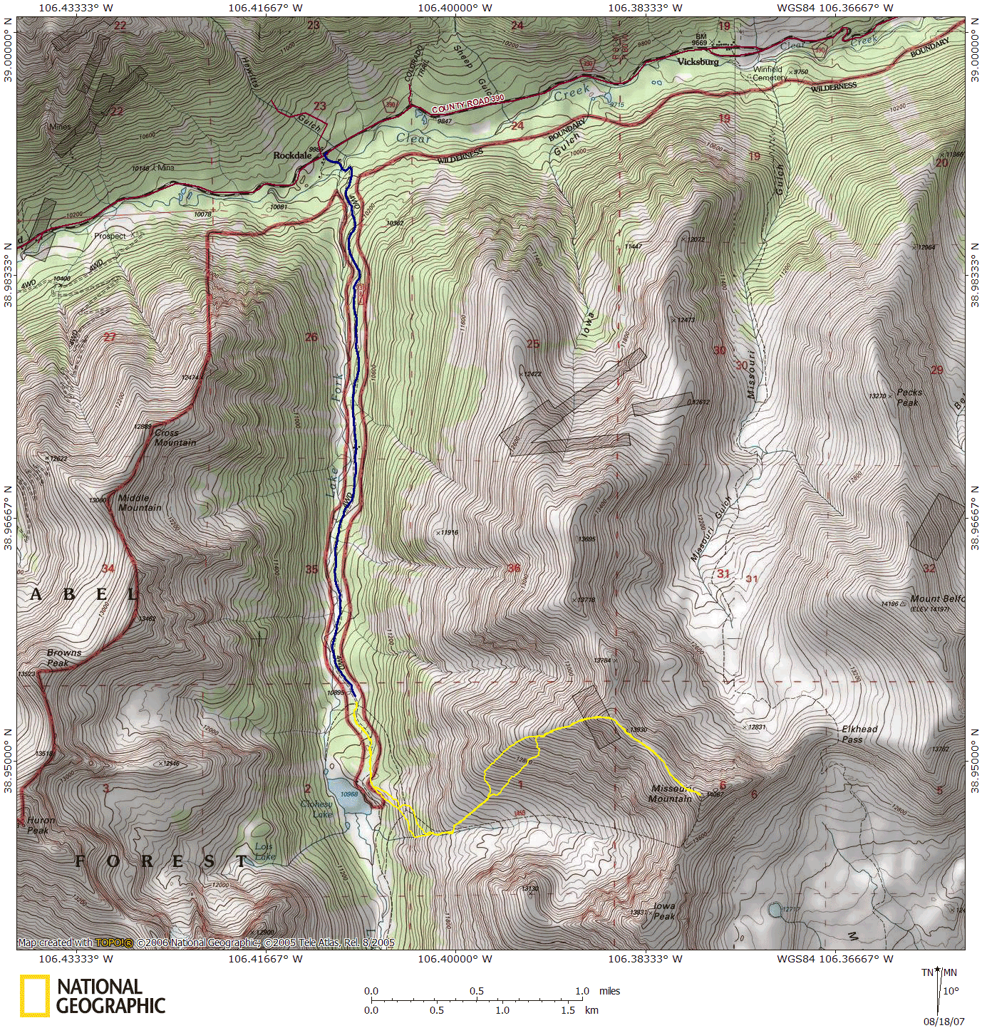
Shari saw that there was another Class 2 route up Missouri from the west ridge. A 4WD road led back farther into the valley, practically allowing you to park at the base of the mountain, eliminating much of the approach that the Missouri Gulch route has. Upon investigation of this route, I discovered that there were two stream crossings required to get onto the 2 mile 4WD road. I posted a thread on 14ers.com asking how bad the stream crossing was, and thankfully multiple people posted responses with tips on how to get through the stream.

Apparently, this stream has floated or flooded the engine of many a vehicle. The trick seems two fold: first, don't do it in the spring! Wait until late July before attempting it. We crossed it in mid-August, and there were parts of it up to my knees, which can easily float a vehicle. After driving past the 5 exciting cabins that are (were) Rockdale, you come across the first crossing, which is the hairiest. You must drive down the stream a short bit to pick up the road on the other side, however if you make a B-line to the road, you'll plunge into a deep spot of the river. Instead, as you enter the stream, you'll see a small island on the left - you want to stay to the left of that island, then hang a sharp right and stay on a shallow shelf that you can follow straight to the road exit on the other side. All in all, at a decent speed, you're in the water for well over 20 seconds.
Once through the first crossing, there's still another, shorter crossing. This crossing is a straightforward crossing from one side to the other, but the road ascends steeply once on the southern side of the stream.
We thought that the stream crossing was really the worst of it, but surprisingly, the 4WD road wasn't exactly great either. Brad, an experienced 4-Wheeler, likened it to the conditions on Engineer Pass. The road wasn't shelfy (except for a short bit) but it was continuously rough without too much reprieve. That said, the Land Cruiser (and probably any stock SUV that's actually designed to go off road) can probably handle it, as long as the driver's got the basics down.

From the turnoff of Highway 24 north of Buena Vista to the trailhead was about an hour, most of which was spent on the 4WD road. We passed a large mud/rock slide that the 14ers.com website described, and found the trailhead not much further. It was easy to spot, given that there were three other vehicles there camping.
We hit the trail with another group (the only other group ascending from that trailhead, actually) at 8:30am - quite a bit later than I had wanted, but the best we could pull of with the group we had. We followed the road past the trailhead sign, and past another sign for the Huron trail until a small trail finally broke off to the left through the trees. We meandered up and over some knolls for a while, with a nice view of Clohesy Lake before the trail really got serious and fast. We noticed, the night before, that the first and last mile of this hike were relatively flat in the elevation profile, which meant that the middle mile had to acquire most of the elevation for the hike...which proved to be very very true.

The trail steeply ascended the grassy hillside. The other party we were hiking behind took a left turn shortly up the hill onto what looked like a shortcut to a switchback, following their guidebook (which I presume was Roach). We continued on, learning our lesson on shortcuts while we were on Sunshine Peak, and the trail got a bit tighter, requiring us to duck under tree branches and step over logs. We were starting to wonder if maybe we should've taken the left turn when we ran into a steeply ascending trail along the stream. According to the map, the stream was where the other trail ended up anyway, so we ascended this route.
It was steep and rocky, with slightly loose soil - not a bad climb, in general. It reminded me of the gully ascent on Mt. Evans or the trough on Longs - though not as slick. After ascending about 200 feet, we ran into the other party. We were both curious to see if these trails truly converged, which thankfully they did. After another 200 feet of ascending the 30% grade, the valley opened up in front of us, yielding the summit of Missouri straight ahead (yet up 2000 feet).
We continued along the trail until about 12,200 feet when the trail finally disappeared into the tundra. By now, it was about 10am, and we had a large, grassy ridge straight ahead of us. Each of us picked our own path: Lisa switchbacked left and right in wide swaths, Lonny powered straight up towards the rocky saddle point, while Shari followed a rocky vein towards the saddle. In the end, it didn't really matter - we still had to climb 1,500 feet in just about three quarters of a mile with nearly a 50% grade at times! The other hiking group apparently decided that the hill wasn't worth it, as they eventually turned back, leaving us to be the only ones on our ascent route.

By 11am, we'd all finally made it to the top of the grassy ridge. We rested for a few minutes before pressing on to the last 500 feet of the ridge. This portion was far rockier, which was a nice break, as it allowed us to scramble a bit, giving our quads a much needed break! By 11:30am, we'd reached the primary Missouri ridgeline, granting us a view of the Missouri Gulch 1,500 feet below. Clouds were covering the skyline by now, making me fairly nervous about the weather, but it was such a hard push to get here, that I was determined to reach the summit.
It took us about another 20 minutes to push the last 0.6 miles to the summit. The trail meandered along the ridge, occasionally dipping down below the narrow ridge summit. About halfway towards the summit, the trail dropped about 30 feet down a steep rocky chute, requiring us to scramble down. Shari and I left our trekking poles next to the trail to pick up on our return, thinking we wouldn't need them for the last push to the summit. Unfortunately, we quickly realized that the trail down below the scramble sloped awkwardly sideways, requiring slow movement to not slip on the loose soil. Poles weren't required, but the additional stability would've been nice.
 that snakes up to the summit")
We finally reached the summit just before noon. The clouds had broken for a few minutes, and the sun was shining, although it was visibly raining south on Mt. Princeton. We returned to the grassy ridgeline a little after 1pm. A rain squall had crested over nearby Huron and was heading our way - thankfully, it was just rain. Rather than descending off the ridge and down into the valley, we decided to follow the ridge crest down quite a ways to a large cairn we spotted on the way up. The ridgeline was a tad more gentle than our ascent route. Once we reached the cairn, we broke left down into the valley, as the ridgeline became steep and unpleasant. Once we started to drop into the valley, we realized why it was we hadn't ascended this way - the drop from the cairn was quite a bit steeper than our ascent was. For a descent, it was still okay, but it probably would've been a harder push to begin with.
Once the terrain began to level out again, another rain storm appeared in the valley, except this one stuck around and brought some lightning with it. Thankfully, by the time we had heard thunder, we were very close to tree line, and starting to descend into the notch carved out by the stream below Missouri. Once in the trees, we broke right to follow the "shortcut" trail the other hikers had climbed that morning. We found this trail to be far more pleasant a descent route than what we came up.
The rain didn't stop until about 2:30pm - by this time, most of us were solidly drenched, but happy to be down. We returned to the car at about 2:40pm, yielding a total hike time of just over 6 hours. Despite the rain, the descent down the 4WD road wasn't too bad - we slid around a bit in some of the muddier puddles near the top, but the rest of the road seemed relatively dry. The stream crossing, as can be seen in the videos, was as uneventful as they could be (thankfully).
When we decided to ascend via the West Ridge, we all thought that we would prefer to avoid the switchbacks and the length of the Missouri Gulch trail, since our memory of it was long and painful. After ascending the West Ridge, however, most of us have probably reconsidered...those switchbacks may have been preferable over the grassy knoll of death. Either way, I believe Missouri is a tough mountain - it rises quickly no matter which approach you take, and I've heard more people on top of 14ers gripe about Missouri than any other - now I know why. It is always fun to take the less traveled route, so from that respect, I think our approach was fun and unique, and I would recommend it to others - just expect your legs to hurt for a few days after!