Hiking Norway’s Jotunheimen National Park - Gjendesheim to Sognefjellshytta
Intro
In 2010, my wife Lisa and I had our first taste of international hut hiking with our hike of the Haute Route and we wanted to do more! We’d always had Scandinavia on our list of places to see, so we began to search for hiking routes there. After doing some research, it seemed that Norway was the best place for hiking (we’d read that Sweden was a bit more swampy and mosquito-y, a fact confirmed for us by some Swedes we’d met along the trail) -- it helped that we tracked down Norwegian Hiking guidebook written in English. Once we decided on Norway, the challenge was to determine where we wanted to hike. It turns out that Norway is HUGE and has lots of hiking throughout the entire country.
We ordered a copy of Walking in Norway by Connie Roos and started reading. After sifting through a number of trail options and regions, we narrowed our focus to Jotunheimen National Park located about midway between Oslo and Bergen at the tip of Sognefjord. This seemed to offer a nice mixture of high mountainous terrain (which I prefer for the views) and valley walks, plus traversing the park was easily accomplished using DNT (Den Norske Turistforening: the Norwegian Trekking Association) and privately owned huts scattered throughout.
This region of Norway (and, from what I can tell, nearly EVERY region of Norway) contains a large network of full and self-service huts. We didn’t want to stay in any self-service huts because we did not want to worry about transporting our own food (or any other logistical necessities that may be required in a self-service hut) so we limited our route to only include full service huts (either private or DNT). We also only had time to spend 5 or 6 days on the trail and many of the books routes were either too short or too long for that time window. Lastly, we wanted to keep the distance of our hike each day to be around 10 miles. The guidebook listed a number of multi-day routes (both loops and through hikes) but all of them were missing some of our key criteria - so I pieced together my own route.
Since our ultimate destination was Bergen, we wanted a through hike to traverse the park. We could have opted to loop back to our starting point but it would have added a significant amount of travel time (via bus, most likely) after the hike in order to drive around the park. The fact that we did not loop back meant we had to pack very carefully since we could not stow a suitcase somewhere and retrieve it later. Our route, however, did allow us to launch out of Oslo (traveling via bus to our starting point of the hike) and finish in Bergen (traveling via bus and ferry through the fjords from our finishing point of the hike) without a significant amount of doubling back.
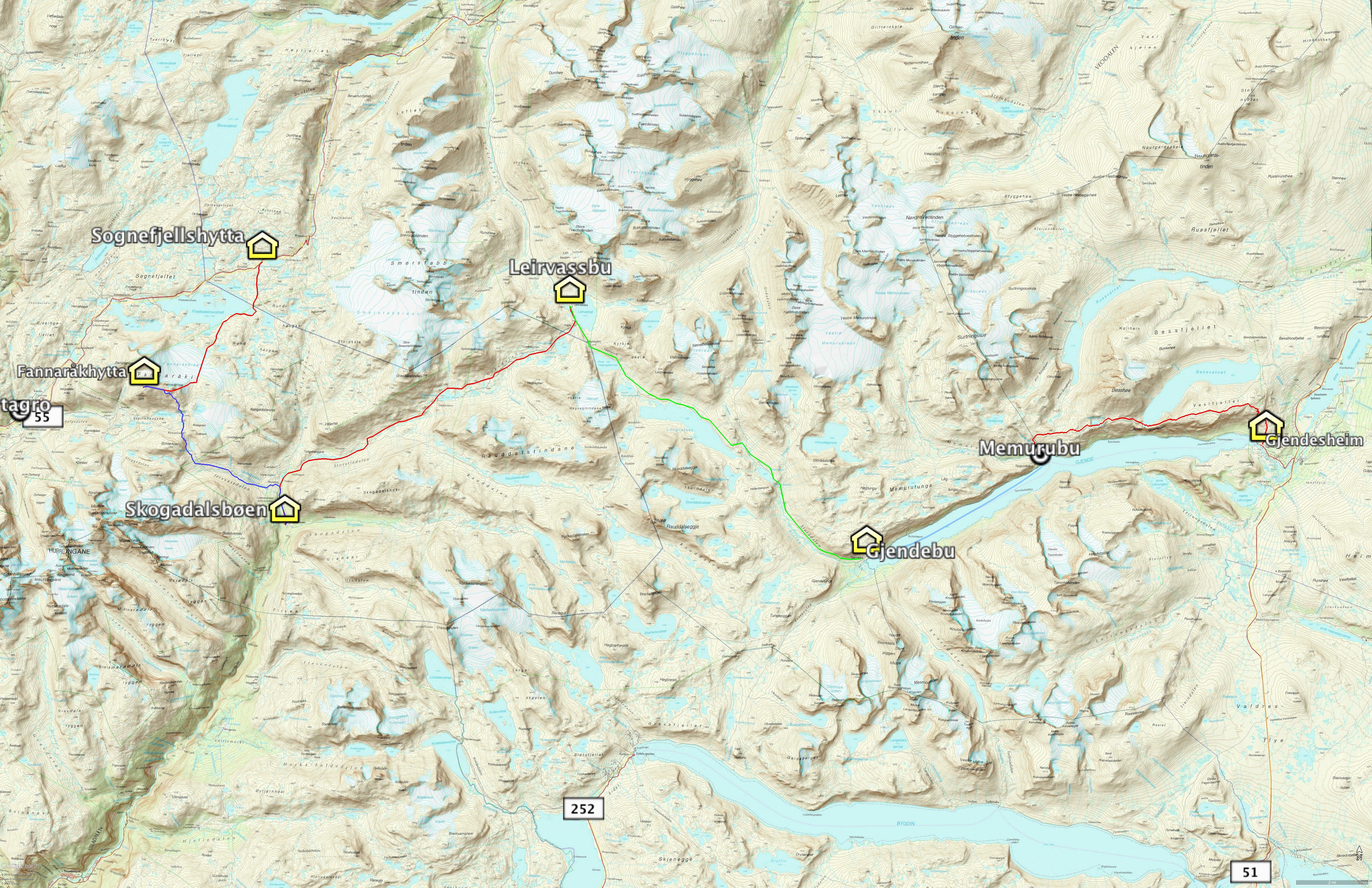
The route we settled on strung together 6 huts and one ferry ride (4 DNT, 2 private) allowing us to hike east to west from Gjendesheim over the “famed” Besseggen ridge to spend a night in the highest lodging in Norway on top of Fannaråki, and finally crossing a glacier down to Sognefjellshytta over the course of 5 days and experience a great cross section of Norwegian terrain.
We found the experience amazing. Surprisingly, the terrain was a oddly similar to high alpine Colorado terrain (except with LOTS more water) since all of our hiking was above treeline (treeline is at about 3,000 feet at this latitude). The mountains were steep and intimidating, but unlike the Swiss Alps, they were much more rounded at the edges and summits (without the jagged peaks and ridgelines that you find in the Alps).
The real appeal of the hike were the people we met along the way – nearly all of the hikers we met at the huts or along the trail were Norwegian and all were very welcoming and hospitable. We learned so much more about the region, the huts, and the country because our fellow hut-mates were so friendly (and gracious enough to converse with us in English). The people we met and our stays at the huts were our favorite parts of the entire hike!
Costs
For your own planning, I’ve included the costs of lodging, meals, and transportation in the spreadsheet below. Keep in mind that these costs were in August 2011. Our lodging choices varied a little at each hut -- where possible, we opted for more private rooms but typically shared a bathroom. All of the huts included the cost of dinner, breakfast and a sack lunch (but had options for lodging only) and we only had wine on our last night (due to its significant cost).
Food
Each hut had breakfast and dinner included and offered a sandwich bar in the morning (included in your lodging fee) so you could pack a lunch for the trail later that day. The items included various meats, cheeses, and veggies to build your sandwich as well as gluten free bread (upon request). In addition to the daily sandwich, we brought enough Clif Bars, Kind Bars, and gel chews from home to last us the entire trip (about 2 bars per day) and this provided good snacks for the trail.
Water
It’s dry in Colorado, so we always carry a 3 Liter CamelBak bladder in our packs (sometimes only partially filled). In Norway, since we’re used to carrying our own water, we filled our CamelBaks up with 3L of water at the start of each day to carry along the hike. We did not realize, however, that this is not the norm in Norway: Norwegians apparently don’t carry 6.6 lbs of water on the trail...they carry a cup. A few times along the trail we’d come across a fellow hiker heading the opposite direction and they’d ask how far it was to the next stream or lake (so they could dip their cup in and drink some water). There is so much (potable) water in Norway that there is apparently no need to carry your own drinking water.
We made this realization a few days into our hike, but we were still too paranoid to rely on mother nature for our water source (so still kept carrying 3 liters of water every day). We did see some signage in the huts warning that 2011 was a lemming year (yup….that’s right: they’re not just a video game) and that the lemming scat may make some water non-potable so this eased our minds that carrying our own water was maybe not such a bad idea; but if you’re looking to shave pack weight, it may be something to consider.
Transportation
We traveled to and from our hike via the Norway bus network -- it’s still astonishing to me that the bus system has stops at these huts in the middle of nowhere. We opted to travel down to Bergen via Sognefjord (for scenic reasons) but we could have made it all the way to Bergen using the bus system as well.
Language
Our total inability to speak Norwegian did not pose any issues at all. We found that every person we encountered (including bus drivers on the outskirts of Jotunheimen) spoke flawless English and didn’t seem to mind conversing in it.
Resources
- Walking in Norway by Connie Roos
- This book contained the richest amount of detail about our hiking route. It was invaluable to have in route planning and during the hike. Since only one chapter covered Jotunheimen National Park, I scanned in the pages that applied to us and carried it with me on my tablet. I believe an eBook version is now available
- Till Topps
- This website has fantastic detail about the routes and supplemented the guide book
- SummitPost - Jotunheimen
- WikiTravel - Norway
- Den Norske Turistforening (Norwegian Trekking Association) Website
- Oslo Tourism Guide
What to Pack
Our pack list was based largely on our previous international hut adventure on the walker’s Haute Route the year before. Based on lessons learned we thinned it down a bit, but once again we had to pack for the trail, and also some time in the city afterwards.
GPS Route
I carried a Garmin Oregon 300 through the entire trick which provided a very accurate track log of our hike. You can download my route for your own navigation as a GPX file (compatible with nearly every GPS receiver, software, and phone apps like Gaia.
- GPX Track and Waypoint File
- Google Earth KMZ file with all considered routes, waypoints, actual track log, and topo map overlay
- JPG Topo Map with route overlay
GPS Basemap Resources
If you plan to bring a GPS, it helps to have a base map loaded onto the unit so you can see landmarks, roads, and terrain features. I've written up some information on base maps on my site and you can read more about it here. Through my searching, I stumbled across an amazing map resource for Norway at frikart.no and I was able to download a complete city map and topo map from that website for free.
Day 0: Arrival at Gjendesheim (August 22, 2011)
After spending a few days in Oslo, we ventured by onwards towards the hike. We opted to travel to Gjendesheim hut via bus as it seemed the most direct route available. We departed from Oslo Bussterminal at 9:30am and rode Fagernes (Bus 160) then transferred to Bus 05-305 to Gjendsheim, arriving at about 3pm. The total journey cost us 570 NOK for the both of us.
Gjendesheim Hut is located just on the edge of Jotunheimen National Park and sits on the shores of the long and narrow (and beautiful) Lake Gjende. We arrived too late in the day to hike, so we opted to spend our first night there in the hut. This was our first exposure to a DNT (Den Norske Turistforening: the Norwegian Trekking Association) hut. The term hut is actually a bit of a misnomer…Gjendesheim is really more like a rustic hotel or lodge that’s made up of a number of sizeable buildings on the eastern shore of Lake Gjende. The central building has a large lounge area as well as the dining hall; next to the main building is a the dormitory with numerous small rooms. Our room was a bit cramped, but offered a bunk bed, a chair, an electrical outlet and some shelves. The dormitory also had a drying room (a feature we found at nearly every hut) which was a heated room with clothes lines running along the top and a fan constantly moving air.
When we checked in, we opted to join the DNT which would lower our rates in 3 of the 5 huts we stayed in. We also informed the hut that Lisa was gluten intolerant – they said that this would be no problem at all.
There were maybe a dozen people at dinner that night – a few that had just arrived like us, but most of whom had taken the boat to Memurubu that morning and hiked back to the hut that day over Besseggen ridge. Two Swedish men sitting at our table had just completed a week-long trip and were celebrating with a much deserved (and extremely expensive) bottle of wine. Everyone at our table spoke perfect English, enabling us to have a very pleasant conversation with everyone. Dinner was delicious: pork, soup, and cheesecake.
Day 1: Gjendesheim to Memurubu (August 23, 2011)
After breakfast at the hut, we began our hike (just before 9am). The trail climbed steeply up to the north of the hut and was well marked with cairns bearing the signature red “T” that we came to rely on over the subsequent 5 days.
As we climbed, the view of Lake Gjende grew more impressive. We could look down below us to see a few dozen people getting onto the ferry to Memurubu – we would encounter most of these people coming the opposite direction along our trail throughout the day. Our direction, however, only had 4 or 5 other folks that we would occasionally spot. Clearly, the most popular direction of this trail is to come from Memurubu – this would indeed have made the ridge a bit easier to traverse!
After a few scrambles (and one fixed chain) we gained one false ridge after another until finally gaining the real ridge after hiking about 2 miles. Once on the ridge, we continued to climb steeply up the wide and barren ridgetop. We were thankful for the sunny day, but the wind blowing across the ridge was cold and so we kept all of our layers on for warmth.
Eventually, the steep climb abated and we continued over gently rolling hills for another half-mile or so before the trail began to descend. The ridge, at this point, was still very wide and offered an amazing vantage over the milky green Lake Gjende and deep blue Lake Bessvatnet.
By noon, the trail had dropped about 400 feet from the top of the ridge and the ridgeline was narrowing. We had reached the Besseggen ridge. I was really very nervous about this stretch of trail. The ridge itself was a narrow point of granite that divided two lakes: Lake Bessvatnet to the north, filled with snow melt and a deep blue color; the other, Lake Gjende, a chalky green color from glacier run off. What makes this ridge particularly spectacular is that Lake Bessvatnet is a steep 800 foot drop to the north, and Lake Gjende is a steep 2000 foot drop to the south. Given the ridge’s narrowness, you are afforded pure unobstructed views of both lakes directly below. It’s phenomenal (if not a bit terrifying).
I’d read plenty about this ridge – it’s one of the most hiked trails in Norway; so from that perspective it can’t be THAT bad…but I’m not a fan of exposure or scrambling. One of the people we spoke to at dinner the night before had indicated that it would be hard going “down the steps” of Besseggen with our heavy pack (which is why so many people opt to climb the ridge from the other side and not descend it like we were).
As the ridge started to narrow, my nerves increased until we were finally at the narrowest stretch. The view was amazing. The slope down to the north was steep, but not sheer. The slope to the south, on the other hand, was sheer. A nice, cliffy 2000 foot drop down to the green lake below. The ridge, at its narrowest, was maybe 5-10 feet wide on solid granite, offering stable footing. A few sections had exposure where I had to get closer to the cliffy edge than I would have liked, but I kept my focus on the task at hand and managed not to freak out. The trail was definitely a Class 3 scramble, which was made more difficult in the fact that we were descending (and not ascending). Many times we found ourselves sitting down on a step of rocks and slowly sliding ourselves down (no more than a foot or two) to the next platform below, which was indeed a tad awkward with our large packs, but still very manageable. We were once again thankful that it was sunny out - I wouldn’t want to do this descent on a rainy day!
The last 100 feet of descent wasn’t bad – the ridge widened back out and the scrambling got easier; the scariest section was really in the middle. Once we reached this section of trail (about 12:15pm) we started to encounter a lot more hikers. So far, we had only encountered maybe 5 or 6 other people on the trail, but now we seemed to be crossing paths with all of those that had taken the ferry to Memurubu that morning. All told, I’m guessing we saw close to 100 hikers coming the other direction that day – crowded for Norway (but nothing compared to a weekend on a 14er in Colorado!)
We opted not to stop for lunch at the base of the ridge since we were on a tight timetable to catch the ferry at Memurubu, but we did take a look back at the ridge from this side. It looked absolutely terrifying! I think had I seen the ridge from this angle I would have freaked out – from the top, it hadn’t looked nearly this scary (and it really wasn’t that bad in the end). If you do opt to climb it from Memurubu, it’s really not as bad as it looks!
As we continued our hike, we climbed and scrambled steeply back up the other side of the hanging valley – another 600 feet in total which was a lot more exhausting than we expected (but thankfully not exposed at all). The trail then continued to drop and climb in a rather tedious manner, but it had great views of glaciers to the north and waterfalls across Lake Gjende to the south. Along the way, we spotted 3 reindeer (really the only wildlife we saw on the entire hike…unless you count dead lemmings).
After about 7.5 miles of hiking the trail drops rapidly, descending 1600 feet in 1.8 miles. The steep descent was made worse by the poor trail condition: the trail was badly eroded, muddy, and very slippery in spots. These things would probably be okay by themselves, but they were exacerbated for us because we were literally running down the trail… Our objective was to catch the 3:05pm ferry from Memurubu to Gjendebu. If we missed this ferry, we’d have to stay in Memurubu for the night which was the only hut that had indicated (via their website) that an advance reservation was required if you required a gluten-free meal and, since it was a private hut, it was much more expensive than the DNT huts (Gjendebu and Gjendesheim). Our timeline was getting fairly tight – it was about 2:15pm when we reached this steep section.
After an extremely rushed descent down to Memurubu, we arrived at the dock just as the ferry arrived from Gjendesheim (thankfully, it had been 5 minutes late!). We watched with fascination as a small crane on the ferry deposited an absurd amount of luggage on the dock of all the passengers and/or those that were hiking the same direction we did during the day.
Finally able to catch our breath, we enjoyed the 30 minute ferry ride to Gjendebu on the surface of the lake that we’d been observing from as high as 2500 feet above it earlier that day. [The ferry allowed us to skip the next section of hiking, from Memurubu to Gjendebu, which was described as extremely steep, requiring a railing to aid in a one hour steep descent…we opted to skip this. Based on conversations with others who had done this section of trail, we chose wisely.]
We arrived at Gjendebu around 4pm. The buildings here seemed older than those at Gjendesheim, but the interiors were nicely remodeled and felt very modern. Our room was more spacious and comfortable than Gjendesheim; again with a bunk bed, a chair, a small desk, and some shelves. The hut had electricity, but no outlets were available in the rooms. Showers were 10 NOK (well worth it!) and the bathrooms were a pit toilet, but still located within the building.
We sat with a few Norwegians and a German couple for dinner. Dinner was fried flounder, fish cakes, tomato soup, and pudding.
Day 2: Gjendebu to Leirvassbu (August 24, 2011)
We departed the hut at 9am, following the clearly marked trail to the north of the hut. Our hike would be a long, slow ascent up a valley towards the private hut Leirvassbu. The trail climbed with a gentle 3% grade for the first 3.5 miles, but it was really muddy requiring a lot of rock hopping to avoid sinking/slipping in the mud. While not difficult, this made the hike very tedious.
As the trail climbed up through the valley, the steep valley walls were decorated with waterfalls, dropping more than 1500 feet down to our level on the valley floor. Some of the falls were tiny ribbons, others were massive torrents of water.
We reached a metal bridge below some impressive falls at about 11:30am, just over 4 miles into our hike. After the bridge, the trail climbed steeply up the side of the falls, reaching the first of four lakes we hiked along for the rest of the day. We climbed another 300 feet before reaching Lake Langvatnet, which translates to “Long Lake”…an appropriate name! We hiked alongside of this lake for 2.6 miles – level terrain but we ended up crossing at least two-dozen streams that fed the lake from the north side of the valley – each one was surprisingly wide and required careful rock hopping to not soak our hiking boots (and socks). When not crossing streams, the trail was incredibly marshy or muddy, also requiring rock hopping to not get submerged ankle deep in marsh. None of this was particularly difficult, but it made a long hike even longer and tedious. In addition to all the rock hopping, a light rain developed along the trail. Thankfully, the wind was blowing from behind us, so the rain stayed mostly out of our faces.
After 11 very monotonous miles of hiking with very gradual incline, we had finally climbed up and out of the valley onto a pass, around 4:15pm. Surprisingly, as we climbed the last pitch to the pass, we noticed an enormous amount of animal scat on the ground…we surmised that it was lemming poo – and it gave us a pretty good idea of just how massive these lemming invasions could be (and why you might not want to drink the water if they’ve been in the area)! It literally coated the ground in every direction!
As we crested the pass (which was also the border of Jotunheimen National park), we could finally see Leirvassbu 500 feet below us (and another mile away). The descent was pleasant enough – at least it wasn’t muddy – but we were really worn out from the day's hike. We arrived at the hut just before 5pm that day.
The term “hut” is really a poor descriptor of Leirvassbu; it is really more like a rustic hotel than a hut. It’s accessible via a dirt road (from the north), so it’s not really off the grid -- it’s just in the middle of nowhere. It’s perched on the edge of a small lake and has private hotel-style rooms (with bathrooms) or dorm-style accommodations. After being soaked all day from rain and being exhausted, we opted for a hotel-style room which allowed us the luxury of a nice hot shower and privacy. Our room was very comfortable – this time with a double bed (not bunk beds), one electrical outlet, and more room to spread out. After showering, we brought most of our clothes down to the drying room. The lobby of the hut had a laptop with internet access, allowing me to fire off a few emails to folks back home.
Dinner was excellent: pork with potatoes, cauliflower, and crème brulee. Unlike all the other huts, everyone had their own tables for dining.
Day 3: Leirvassbu to Skogadalsbøen (August 25, 2011)
We set out from the hut around 9:15am to a rainy and foggy morning. We wore our raincoats, rain pants, and pack covers to fend off the light drizzle that was periodic throughout the day.
We started out heading south and followed a dirt road (instead of the muddy trail, which paralleled the road) heading southwest for the first 4 miles making for an easy descent. As we hiked, we could see the tail ends of glaciers clinging to the mountains above us, but the fog prevented much more of a view.
About half way through our hike (12pm) we encountered a dam in the middle of nowhere holding back the most brilliant turquoise water I’ve ever seen. After exploring for a few minutes, we departed the road and followed the trail where we were reminded of why we had avoided it earlier in the day: it was soggy and swampy. The views became much less dramatic past the dam as well - the high peaks, glaciers, rocky surfaces, and short vegetation gave way to more rolling greenery with taller and more diverse plants (the views might have been more impressive without the fog, but we really couldn’t tell).
The trail was rocky, marshy, slippery, and extraordinarily muddy from this point on for the day. The few portions of trail that crossed solid rock was slippery, but everywhere else it was just marshy. We spent a lot of time looking down at our feet to focus on rock hopping or avoiding sinking into the mud. With my rain pants and waterproof boots on my socks still ended up soaking through. In hindsight, wearing our gators might have come in handy here.
The trail markers were fainter along this trail than the previous days, but the trail was still easy to follow (since it was typically a light stream). After crossing a wooden bridge around 2pm and joining the Olavsbu trail, the route got a little more solid but it was still a sloppy mess.
Once the trail reached the end of the valley and joined with other adjacent valleys the trail dropped quickly and steeply down towards the hut. The exposed tree roots and rocks along this section of steep trail made for a slippery (and slow) descent and it took us another hour before we reached the hut.
We arrived at Skogadalsbøen at 5:15pm after hiking 12 soggy and muddy miles. The hut was much more rustic (and smaller) than our previous accommodations but very homey. It appeared to be much more “off the grid” than our previous huts. We had a private room with no electricity or lights in our room, just a single small candle. Showers were 20NOK and a drying room (with a large basin for washing clothes) was available. The outhouses and showers were in a separate building from the main bunkhouse.
We asked the hut proprietors at Skogadalsbøen about the muddy trail conditions and he said it’s usually not this bad -- it had just been a particularly rainy year. This sentiment was echoed by four other Norwegians we had met at dinner who had indicated that hut use had been down this year due to the heavy rain...so take heart: it may not be this wet when you hike it!
Our dinner was a bit simpler than at the other huts but it was still very good and Lisa’s gluten intolerance was not an issue. We dined on moose, and then had mousse with cloudberries for dessert. There were only four other people at dinner; three Norwegians and an Italian. Once we sat down for dinner and they realized we only spoke English everyone at the table switched to speaking English in deference to us! They ended up being wonderful dining companions and we had a great evening with them (discussing, among other things, the finer points of how Norwegians closely guard the secret of their cloudberry fields).
Day 4: Skogadalsbøen to Fannaråkhytta (August 26, 2011)
After breakfast (at 9:15am) we retraced our steps northbound to head off towards Fannaråki. Whereas the day before we mostly descended, we would make up for that by climbing over 4000 feet today. Thankfully, we awoke to a little bit of sunshine and dry(ish) air which made the hike a bit more pleasant than the soggy day before.
Rather than wearing our rain pants, we opted to wear our gators to try to keep the moisture from soaking our feet again. The trail was still pretty soggy until about halfway through the meadow towards Fannaråki. The trail was easy to follow until the pass at 4.5 miles (which we reached around 1pm); at that point the markers became a bit sporadic for about a mile. This was our first view of Fannaråkhytta up on top of the mountain.
As we climbed up on to the mountain, the terrain changed from soggy alpine tundra to a rocky mountainside. We crossed two minor snowfields (one of which could have been avoided), neither of which was difficult at this point in the season. The trail became increasingly rocky requiring some rock hopping and even some minor scrambling, which was a bit of a pain on my wet aching feet -- through all of this, however, the trail was still well cairned.
We arrived at the hut just before 4pm. We had good visibility during our hike, but the clouds were descending fast. Later that night (at 6pm) the visibility on top of the mountain dropped down to about 20 feet -- had this happened while we were on the trail, a GPS would likely have been critical to ensure you didn’t wander off trail too far.
The hut (Fannaråkhytta) is made up of three separate buildings on top of the mountain: the dining hall, the dorms (perched at the very top), and the outhouses. They’re all about 500 feet away from each other with rocky talus in between. The building separation wouldn’t normally be a big deal except that while we were at dinner the winds picked up to about 60 mph and it started raining extremely hard...and our rain gear was with our packs in the bunk house. I strongly recommend you have your rain gear with you at all times up here!
The bunkhouse was fairly minimalistic and despite its tiny size it’s apparently slept up to 85 during a bad storm -- DNT never turns people away for lodging, so they’re prepared for the worst (with mattresses piled high everywhere). A drying room was available, but it was not heated (at least not at the time). Drinking water was available about 70 meters back down the trail from the outhouses.
Dinner was a barley and meatball soup but it had wheat in it, so they had to improvise for Lisa and brought her some ham for dinner instead. After dinner, all of us staying at the hut that night waited in the dining room as long as we could until we finally had to brave the elements and run through the driving rain back to the dorms. The wind howled all night and I just hoped I didn’t have to get up to use the outhouse in the middle of the night.
Day 5: Fannaråkhytta to Sognefjellshytta (August 27, 2011)
The rain had let up a bit in the morning for breakfast, allowing us to move between buildings without getting totally drenched (if only for a few minutes). Breakfast was very simple: bread (gluten free for Lisa), oatmeal, cheese, salami, and jam.
After breakfast, we met our guide (Tobias) who would be taking us down the glacier towards Sognefjellshytta. It cost us each 125 NOK which included a pair of half crampons that strapped on to our hiking boots. Half crampons only provide spikes over your heel and not the ball of your foot -- this proved to be a bit of a challenge for most of us and led to a LOT of falling on the glacial ice.
There were 12 of us that stayed at Fannaråkhytta the night before but 4 of them were headed back towards Skogadalsbøen, then on Sognefjellshytta (which seemed to be a common 3-day loop). 2 others (Frederich and Thomas) had hiked up the day before from Turtagrø and were joining us on the glacier.
We began our descent back down the same rocky trail we had ascended the day before, only the wind and rain from the night before had returned. It was absolutely pouring. At 1.5 miles (and after dropping 1370 feet) we departed our original trail and began heading towards the glacier through rocky section that has obviously been scoured by the retreating glacier. We hiked another half mile (and climbed another 260 feet) before reaching the ice. We put our crampons on as we reached the glacier and were roped together by our guide at 12pm. Our guide was the front of the rope, then me, followed by Lisa, then the two Norwegians. The rope, combined with the bizarre half crampons, proved to be a big challenge.
The glacier was solid ice with a sheet of rain water washing over the top. We were all expecting a snowy top to the glacier which would have provided better traction than rock-solid ice. The crampons only provided traction if you stomped your heel down into the ice, and if you began to lose your balance and shifted your weight to the ball of your foot, the wet ice was unforgiving and you’d slip and fall over (and the ice, being rock hard, left a LOT of bruises the next day...or for the next month). As we all attempted to walk out onto the ice, we all struggled with getting the right amount of traction and many of us fell...this added tension to the rope, which then caused others to fall. It took about 20 minutes for us to somewhat get the hang of walking down the ice this way -- we had to maintain a good amount of slack on the rope (in case someone else fell over) and very carefully kick our heels in as we walked...all of this in driving 60 mph winds with pouring rain.
Our guide started by showing us the entrance to a crevasse that was opening at the edge of the ice and then we began our traverse across and then down the ice. The visibility was perhaps only 20 feet at this point so there wasn’t much to see (besides, we were all too busy trying not to fall over that we were a bit distracted). By now, I was soaked -- less from the wind and rain and more from falling repeatedly onto the ice (and the sheet of water flowing over the top of it). To add to the excitement, the wind ripped Lisa’s pack cover off and it quickly disappeared out of view. It was easy to push all of this discomfort out of my mind since I was basically just terrified of falling again as we tried to follow an icy ridgeline that proved extremely tough to stay upright on. We ascended another 150 feet once we were on the ice, gaining a small icy ridge before beginning our descent -- this climb was the most challenging part as we were all still getting used to being roped together and using our crampons.
On our way down, we saw a few dead lemmings either on the ice or caught in small pools of water. Our guide pointed out some 300 foot deep holes, crevasses, and raging rivers of water that carved through the glacier. Visibility improved a bit as we descended, and the wind died down a little (although the rain continued to pound us) and we could see some more of the interesting contours of the glacier, including what appeared to be a giant bullseye in the ice. We all got better at keeping our balance and not falling on the ice over time, but it was still very difficult to get the crampon spikes embedded in the ice as we walked. Towards the end, we kind of started to enjoy it….sort of.
We reached the other edge of the glacier at 2:15pm -- about two hours and fifteen minutes total on the ice (longer than it typically takes). We were on the ice for 1.25 miles and descended about 800 feet. We still had another 4 miles (and 900 feet of descent) in front of us for the day. At the edge of the glacier we met up with the group waiting to ascend the ice to Fannaråkhytta that night. They warned us that the bridge across the stream down the trail was completely submerged by all the rainwater coming off the glacier and advised us to cross (with our boots on) as close to the bridge as possible (apparently they had attempted a number of locations to cross the stream and decided the best spot was to follow the trail). We thanked them for the info and all four of us headed down the trail as they roped up for their ascent.
We reached the stream about 30 minutes later and, indeed, it was a torrent of water. The bridge was still visible and itself above the water (just barely) but each side of the bridge was about 6 feet from the edge of the stream. Each of us slowly stepped into the rushing water to cross about thigh-deep -- most of us were drenched from the rain and falling on the glacier, so this just added to the excitement of the day. The water was fast moving but navigable and all of us made it across okay.
As we continued down the trail we encountered numerous deep streams that required wading (only about calf deep) -- our legs were soaked already so we just plowed through them. The wind and rain eventually let up which made the hike a bit more pleasant, but we were all soggy and miserable at this point. Once we left the glacier, we hiked for another 2 hours (around the lake) until we finally reached our ultimate destination of the hike at 4:30pm: Sognefjellshytta.
Upon arrival, we emptied absolutely everything out of Lisa’s pack to let it dry. The drying room was completely filled with others’ gear (tents, sleeping bags, clothing). We found some spots for our soaking wet clothing and the spread the items from Lisa’s pack around our room. Somehow her tablet and phone didn’t get wet, but everything else (including her passport) was soaked through completely (an important lesson: always put items in your pack into a ziploc or dry bag!).
That night at dinner we splurged and bought the first (and only) bottle of wine we had in Norway. It was about $80 USD (for about an $8 bottle you could get here in the States) and it was amazing. Thomas and Frederich ended up staying in Sognefjellshytta for the night (they had intended to take a bus back to Turtagrø but they were full up for the night) so we ended up talking with them for a few hours after dinner and getting to know them quite well!
The following morning we departed Sognefjellshytta via bus at 10:00am and rode about 3 hours (via Bus Route 23-190, 190 NOK) to Sogndal. The Sognefjord ferry didn’t depart again until the morning, so we stayed the night in Sogndal. Just as a traveler’s note: there’s not much to do in Sogndal -- we wandered through town a bit but it was drizzling and much of our gear was still wet from the previous days’ adventure, so we ended up just nestling into our hotel room and reading. We departed the next morning at 7:05am on the Sogndal to Bergen ferry (880 NOK), traveling down the beautiful Sognefjord, arriving in Bergen just before noon.
Overall Thoughts
We had set the bar high by doing the Haute Route the year before - 9 days of hiking in the Alps with bluebird skies is a tough adventure to beat. We had a lot of fun hiking in Norway, but we found the scenery to be a bit less than we expected (still awesome, but not quite as grand as we had hoped), the weather to be quite a bit less than we expected (there’s really only so much rain that it’s fun to hike in), and the trail conditions to be less than we hoped (due to the recent rains….not due to neglect). I suspect that if we had better weather our experience would have been much more positive, but it kind of put a damper over the whole trip.
Don’t get me wrong: I would strongly recommend this trip, or any other Norwegian hiking trip to anyone. Norway, like Switzerland, seems to raise hiking up to the level of a national pastime -- their trail network and hut system is absolutely amazing (and puts anything in the US to shame). Major bus lines travel to these remote huts. Selecting a route is nearly impossible because there are SO many different route options available. The Norwegians KNOW hiking!
I would happily hike in Norway again; the friendly people, great views, and awesome trail network are fantastic. I would recommend this hike to anyone, but if I were to do it again, I would avoid crossing the glacier on Fannaråka -- the experience was just too intense for me (and again, this may have been amplified by weather). Staying up at the top of the mountain in the highest lodging in Norway (Fannaråkhytta) was worth it, so I would just recommend an alternate way down...but that’s just my taste and my degree of adventure seeking.