Handies Peak (14,048 ft)

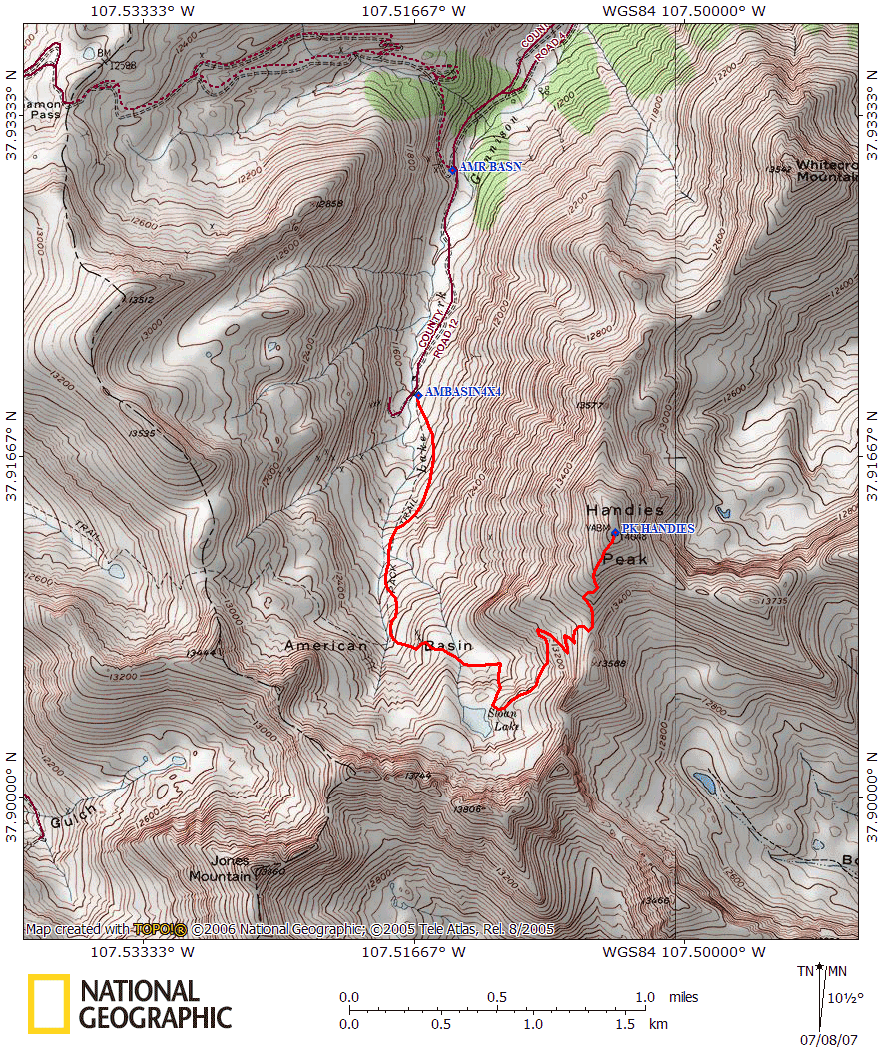
After summiting Redcloud and Sunshine the day before, we camped a second night at the Silver Lake/Grizzly Gulch trailhead (who can give up the luxury of pit toilets?). We (Lisa and I, Shari and Brad, Lonny, and Tracy) packed up the car and hit the road by 7:00am, reaching the turn off from Cinnamon Pass to American Basin at 7:30am. A few minutes later, we reached the stream crossing. A Toyota Highlander and Subaru Outback had apparently thought better of trying to ford the stream, so they had parked in a small parking area off to the left. Both the 4Runner and the Land Cruiser made it across without incident, although the water was close to the bumper of both. Not far past the stream crossing, we reached the trailhead. There were a few cars at the trailhead, plus a tent. We ended up hitting the trail at about 8am.

A friend of mine had told me that the wildflowers in the American Basin were spectacular. Unfortunately, it seems that we were a tad too early for them. In talking to the owner of the Wyman Inn in Silverton later that day, it sounded like the American Basin was filled with snow just a week or two prior. I'm sure late July the flowers are beautiful - however even without flowers, the American Basin held spectacular views.
This hike promised to be far easier than Redcloud and Sunshine of the day before - we started nearly 1600 feet higher, and the whole trip was less than half the distance of the previous hike. That said, most of us moved a bit slower given that our bodies were a bit worn from the day before. As we ascended the trail, we noticed rather quickly that we'd be dealing with snow more on this hike than the day before. The basin still held an awful lot of snow, some of which crossed the trail. This required us to do a bit of route finding when a snow field covered the trail. This didn't prove to be too difficult, as the trail was fairly solid and could typically be spotted when it was lost.
We reached the half-frozen Sloan Lake (12,900 feet) at about 9:30am. This marked about the half-way point, both in elevation and distance. From here, the trail continued to contour around the end of the rocky basin (in our case, across a snow field), and then up a set of long switchbacks that drew you up to the ridgeline of Handies. We took our time across the snow field clinging to the rocks and started to ascend the switchbacks. At this point, we were passed by four runners who, we found out later while talking to them on the summit, were training for the upcoming Hardrock 100 Mile Endurance Run which travels from Grouse Gulch up and over Handies, down to the Silver Creek/Grizzly Gulch trailhead where we camped the night before (suddenly we felt silly being tired on such a short hike!)

We completed the switchbacks by 10:15, reaching the ridge that divided the American Basin with Boulder Gulch, which offered a fantastic view (actually, this entire hike offered fantastic views). Unfortunately, the easy part was over. The trail to here had been a fairly gentle grade, solid footing, and nicely switchbacked. From the ridge at about 13,500 feet, the trail switchbacked a bit, but generally it just went straight up at about a 27% grade the last 500 feet. The trail footing was far more solid than that on Redcloud, but it was a strenuous push to reach the summit. Oddly enough, about 200 feet below summit, two F-16s (or something...no one really knew what they were) flew by, probably at an altitude of 14,000 feet! It's quite something to see those things fly by at near eye-level!

We all slowly plodded up the mountainside, eventually reaching the summit at about 10:50am. Unlike the day before, the summit of Handies had a few people on it - including a family of 6 from Ireland! The skies were completely clear and the view was phenomenal. Someone on the summit said that Backpacker magazine rated Handies the best 14er summit for the view, and I must agree. You look around in every direction and there's absolutely no sign of civilization except for the top of Cinnamon Pass, which is barely visible. All that surrounded us were peaks and ridgelines...it was beautiful!
We relaxed on the summit for quite a while, talking with the Irish family (in the States for 9 weeks!), talking with the runners training for the Hardrock (it was apparently trail marking day for Handies), and talking with the others that arrived on the summit after us. We left the summit at about 11:30am, passing a number of people ascending as we hiked down the steep final pitch.
By 12:30, we'd returned to the Sloan Lake area, and had decided to take advantage of a large snowfield which reconnected with the trail about 150 feet below. Brad was the first to try out the glissade, and found it to be quite pleasant. We all followed, descending rapidly (and cooling off quite nicely as well) - other hikers behind us also decided it seemed like a good idea too and followed.

The snow had softened a bit since the morning, and we found ourselves post-holing occasionally on the descent, as well as getting a bit muddy where the trail had runoff running down it; but it wasn't a bad descent. We returned to the trailhead around 1:30 and saw that there was now about a dozen vehicles there, including a few ATVs. It seems the American Basin is a popular stop for people driving over Cinnamon Pass - people had set up picnics and were enjoying the mountain stream.
After cooling ourselves a bit in the stream, we returned to the car to head out to crossing. We ended up giving a ride to two gentlemen who had ridden up in the Highlander and parked on the other side of the stream. Apparently, the stream didn't offer a very appealing crossing point for those on foot and neither relished the idea of fording it again. On the other side of the stream, we dropped them at their vehicle, and headed off to drive over Cinnamon Pass, arriving in Silverton around 4:45pm (we did stop at the pass summit and Animas Forks to have a look around).
Handies was a wonderful hike. From the American Basin, the trail was very solid and mostly gentle (except for the last 500 feet of elevation), and the view was phenomenal the entire way. If the wild flowers had been in bloom, that would've made it even more spectacular. Unfortunately, the American Basin does require a decent clearance four-wheel drive to get there...although an Outback and Highlander did make it close (the guys from the Highlander did say that they scraped bottom at one point). Alternatively, the Grizzly Gulch trail doesn't require four-wheel drive, but it's a bit longer (and not as pretty). If you plan on heading over Cinnamon Pass afterwards, you'll no doubt encounter plenty of idiots on the road that will slow you down (we certainly did), so just plan accordingly.